
Local time Tuesday 1:05 PM | ||
 | ||
Weather 13°C, Wind W at 21 km/h, 27% Humidity | ||
Devils Elbow, Missouri is an unincorporated community in Pulaski County on historic U.S. Highway 66. It is situated on the Big Piney River and was named for a particularly bad place in the river known as a "devil of an elbow". It is about five miles (8 km) east of St. Robert.
Contents
Map of Devils Elbow, MO 65457, USA
History
A post office called Devils Elbow has been in operation since 1927. The community took its name from a nearby meander on the Big Piney River.
Transportation
The major east-west route is Interstate 44; before that, the main highway was U.S. Route 66, which still exists as a scenic route through the area and passes through Devil's Elbow, St. Robert, Waynesville, Buckhorn, and Hazelgreen. Names for U.S. Route 66 vary - at different places, it is called Teardrop Road, Highway Z, Old Route 66, Historic Route 66, and Highway 17. State-posted signs mark most of the alignment of the road.
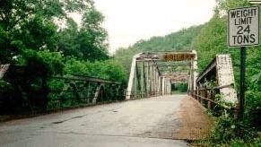
The original alignment of U.S. Route 66, now known as Teardrop Road, runs through Devil's Elbow and is the site of the historic Devil's Elbow Bridge. A later realignment, Highway Z, runs near Devil's Elbow and bypasses the community.
Three bridges cross the Big Piney River at Devils Elbow—the modern Interstate 44 bridge, the later U.S. Route 66 alignment on Highway Z that was made possible by the Hooker Cut through a steep hillside, and the original U.S. Route 66 alignment on Teardrop Road that includes a historic bridge that's in the process of renovation. The Elbow Inn is a biker bar that is a frequent stop on the original U.S. Route 66 alignment.