
Country United States Time zone Pacific (UTC-8) Elevation 486 m Population 209 (2013) | Incorporated 1952 Zip code 97342 Local time Tuesday 6:27 AM | |
 | ||
Weather 2°C, Wind S at 14 km/h, 89% Humidity Area 249 ha (153 ha Land / 96 ha Water) | ||
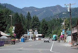
Detroit is a city in Marion County, Oregon, United States. It was named for Detroit, Michigan, in the 1890s because of the large number of people from Michigan in the community. The population was 202 at the 2010 census. It is part of the Salem Metropolitan Statistical Area.
Contents
Map of Detroit, OR 97342, USA
History
The original townsite of Detroit was inundated in the summer of 1952 when the Corps of Engineers finished Detroit Dam on the Santiam River. The community was relocated about 1⁄2 mile (0.80 km) northwest of the original site, on Route 22, and was incorporated as a city the same year.
Located near Detroit Lake and Detroit Lake State Park, Detroit's economy is dependent on tourism. The community suffered from a drought in 2001, when Detroit Lake was little more than the Santiam River through the summer.
In 2010, by a vote of 47–37 citizens in Detroit voted down a ballot measure that would have changed the city's name to Detroit Lake, the name of the neighboring reservoir and one of the most visited summer sites in Oregon. The proposal was put forth by Doug DeGeorge, a builder and motel owner who resides in Arizona and wanted to disassociate the town from Detroit, Michigan, and its close ties to "crime, corruption, failing schools and a shaky auto industry". Doug DeGeorge was not present on the day of the city council vote, but repercussions from his comments had phone lines flooded with angry calls from Michigan residents. Voters chose to keep the original name of the city, however, most residents and tourists still call it Detroit Lake. Gary Brown, a city councilman in Detroit, Michigan, disagreed with the proposal, saying local residents would have made a big mistake because the Motor City will one day return to its previous glory.
Geography
According to the United States Census Bureau, the city has a total area of 0.96 square miles (2.49 km2), of which, 0.59 square miles (1.53 km2) is land and 0.37 square miles (0.96 km2) is water.
Climate
This region experiences warm (but not hot) and dry summers, with no average monthly temperatures above 71.6 °F (22.0 °C). According to the Köppen Climate Classification system, Detroit has a warm-summer Mediterranean climate, abbreviated "Csb" on climate maps.
2010 census
As of the census of 2010, there were 202 people, 96 households, and 59 families residing in the city. The population density was 342.4 inhabitants per square mile (132.2/km2). There were 368 housing units at an average density of 623.7 per square mile (240.8/km2). The racial makeup of the city was 95.5% White, 1.5% Native American, and 3.0% from two or more races. Hispanic or Latino of any race were 3.0% of the population.
There were 96 households of which 19.8% had children under the age of 18 living with them, 53.1% were married couples living together, 7.3% had a female householder with no husband present, 1.0% had a male householder with no wife present, and 38.5% were non-families. 30.2% of all households were made up of individuals and 9.4% had someone living alone who was 65 years of age or older. The average household size was 2.10 and the average family size was 2.64.
The median age in the city was 51.4 years. 18.3% of residents were under the age of 18; 4% were between the ages of 18 and 24; 13.9% were from 25 to 44; 48.1% were from 45 to 64; and 15.8% were 65 years of age or older. The gender makeup of the city was 49.5% male and 50.5% female.
2000 census
As of the census of 2000, there were 262 people, 119 households, and 69 families residing in the city. The population density was 496.7 people per square mile (190.9/km²). There were 383 housing units at an average density of 726.2 per square mile (279.0/km²). The racial makeup of the city was 96.56% White, 1.15% Native American, 0.38% from other races, and 1.91% from two or more races. Hispanic or Latino of any race were 3.82% of the population.
There were 119 households out of which 21.8% had children under the age of 18 living with them, 47.1% were married couples living together, 10.1% had a female householder with no husband present, and 41.2% were non-families. 33.6% of all households were made up of individuals and 16.0% had someone living alone who was 65 years of age or older. The average household size was 2.20 and the average family size was 2.77.
In the city, the population was spread out with 22.1% under the age of 18, 5.0% from 18 to 24, 23.3% from 25 to 44, 33.2% from 45 to 64, and 16.4% who were 65 years of age or older. The median age was 45 years. For every 100 females there were 103.1 males. For every 100 females age 18 and over, there were 100.0 males.
The median income for a household in the city was $32,250, and the median income for a family was $35,156. Males had a median income of $41,875 versus $22,188 for females. The per capita income for the city was $19,857. About 17.9% of families and 16.1% of the population were below the poverty line, including 44.1% of those under the age of eighteen and none of those sixty five or over.
Education
Detroit is served by the Santiam Canyon School District, whose schools are located in nearby Mill City, Oregon.