
- elevation 222 ft (68 m) Length 19 km Basin area 4,740 km² | - elevation 164 ft (50 m) Discharge 218.4 m³/s Basin area 4,740 km² | |
 | ||
- average 7,714 cu ft/s (218 m/s) - max 202,000 cu ft/s (5,720 m/s) Sources North Santiam River, South Santiam River | ||
Oregon gold prospecting little north fork santiam river
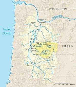
The Santiam River /ˌsæntiːˈæm/ is a tributary of the Willamette River, about 12 miles (19 km) long, in western Oregon in the United States. Through its two principal tributaries, the North Santiam and the South Santiam rivers, it drains a large area of the Cascade Range at the eastern side of the Willamette Valley east of Salem and Corvallis.
Contents
- Oregon gold prospecting little north fork santiam river
- Map of Santiam River Oregon USA
- Opal creek little north santiam river oregon whitewater kayaking
- References
Map of Santiam River, Oregon, USA
The main course of the river is short, formed in the Willamette Valley by the confluence of the North and South Santiam rivers on the border between Linn and Marion counties approximately 8 miles (13 km) northeast of Albany. It flows generally west-northwest in a slow meandering course to join the Willamette from the east approximately 8 miles (13 km) north of Albany.
Both the North and South Santiam rise in high Cascades in eastern Linn County. The Middle Santiam River joins the South Santiam where the South Santiam is impounded to form Foster Lake. The North Santiam is impounded to form the 400-foot (120 m) deep Detroit Lake in the Cascades. The Santiam is a major source of water supply for Salem.
The Great Willamette Flood of 1861, which crested on December 2, destroyed a large number of structures and animals on prairies near its confluence with the Willamette River and south of Knox Butte.