
Isolation 19.0 km (11.8 mi) Elevation 3,257 m First ascent 1784 | Listing Ultra Prominence 1,796 m | |
 | ||
Similar Haute Cime des Dents du, Mont Blanc, Dents Blanches, Grand Muveran, Dent de Morcles | ||
Hte cime des dents du midi
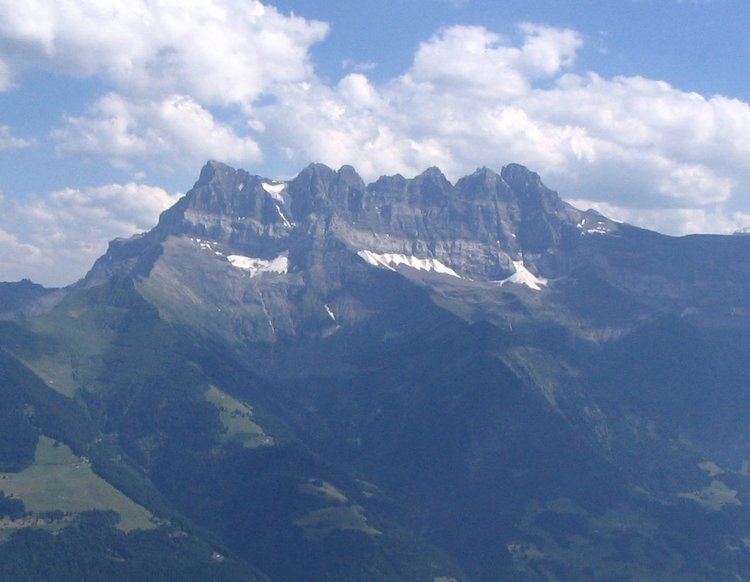
The Dents du Midi (French: "teeth of noon") are a multi-summited mountain situated in the Chablais Alps in the Swiss canton of Valais. They are composed of seven distinct summits and reach a height of 3257 metres (10,686 feet). Highest mountain between Lake Geneva and the Mont Blanc Massif, they dominate the Val-d'Illiez and the Rhône Valley, from Martigny down to the lake. Together with the slightly lower Tour Sallière, they form a cirque around the Lac de Salanfe, an artificial reservoir. Geologically it makes up a part of the massif Haut-Giffre.
Contents
- Hte cime des dents du midi
- Map of Dents du Midi 1873 Val dIlliez Switzerland
- Ski extreme dents du midi direct de la forteresse version courte
- The seven peaksEdit
- RockfallsEdit
- Origin of the nameEdit
- LperonEdit
- References
Map of Dents du Midi, 1873 Val-d'Illiez, Switzerland
Ski extreme dents du midi direct de la forteresse version courte
The seven peaksEdit
The "Dents", or "Teeth" are, from east to west:
RockfallsEdit
On the morning of October 30, 2006, a mass of 1,000,000 m³ (35,300,000 ft³) of rocks detached themselves from the side of the Haute Cime and fell down the side to an altitude of about 3,000 m (9,800 ft) The event did not pose any danger for the nearby town of Val-d'Illiez but roads and footpaths were closed as a security measure. According to the geologists of the canton, the landslide was caused by thawing, assisted by the hot summers of the preceding years.
Shortly after midday on Friday 17 August 2012, another significant rockfall occurred below the Cathédrale, amounting to at least 100,000m³ of rock. Twelve hikers were rescued by helicopter, All were unscathed, as was a flock of sheep grazing nearby. Again, the fall was put down to exceptional heat locally.
Less serious falls continued over the next few days and hiking trails remained closed.
Origin of the nameEdit
The name "Dents du Midi" is of relatively recent origin. The native inhabitants originally called them the "Dents de Tsallen" ("teeth of Tsallen"). The present Haute Cime was then called Dent du Midi, and it eventually gave its name to the entire mountain.
Each peak, or "tooth", has had several names over the centuries:
L’ÉperonEdit
Several ruptures in the massif have changed the form of the peaks so much that the names adapted themselves according to the geological evolution. L’Éperon (The Spur), for example, no longer has two summits, since a landslide in the Middle Ages significantly changed this peak.