
- elevation 2,823 ft (860 m) | - elevation 984 ft (300 m) | |
 | ||
- location Big Delta, Southeast Fairbanks Census Area | ||
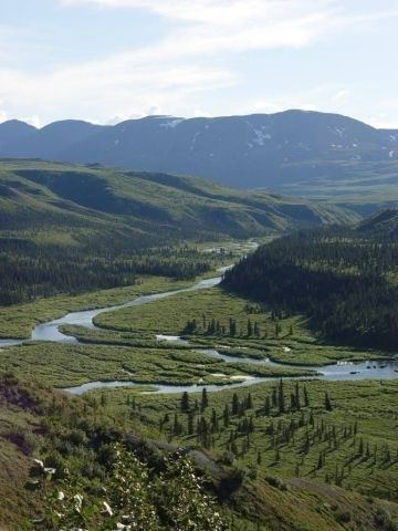
The Delta River is an 80-mile (130 km) tributary of the Tanana River in the U.S. state of Alaska. Its name in the Ahtna language is Saas Na’ . Fed by the Tangle Lakes of the Alaska Range, the river flows north to meet the larger river near Big Delta.
Contents
In 1980, 62 miles (100 km) of waterways in the Delta River basin, including all of the Tangle Lakes and the main stem to within 0.5 miles (0.8 km) of Black Rapids became part of the National Wild and Scenic Rivers System. Of this, 20 miles (32 km) are designated "wild", 24 miles (39 km) "scenic", and 18 miles (29 km) "recreational".
Boating
Easily accessible from the boat launch at the Tangle Lakes campground near the Denali Highway and at many points downstream along the Richardson Highway, the river can be floated in sections that vary in difficulty from Class I (easy) to Class V (extremely difficult) on the International Scale of River Difficulty and may require portages. The upstream stretches include four lakes and their Class II (medium) connecting channels. About 2 miles (3 km) downstream of the last lake, the river enters a canyon and flows over unrunnable waterfalls. A 0.5-mile (1 km) portage leads to a 2-mile (3 km) stretch of Class III (difficult) rapids.
Below the Class III rapids, the river continues through 29 miles (47 km) of Class I and II water before entering a 20-mile (32 km) stretch between Ann Creek and One Mile Creek known as Black Rapids. Here the difficulty is Class III rising to Class IV (very difficult) or V, followed by 30 miles (48 km) of Class III and then 18 miles (29 km) of Class I.
Author Karen Jettmar warns of dangers including "sweepers, canoe fragments wrapped around rocks, bears, cold and wet weather, and high winds". She says that "only experts should attempt to run Black Rapids (Class IV–V) below Mile 229 on Richardson Highway."
Fishing
The Tangle Lakes complex, 24 miles (39 km) long, that feeds the Delta River has "some of the best road-accessible grayling fishing in Interior Alaska". In the deeper lakes of the system, lake trout are fairly abundant. Lakes and streams that are away from the highway and accessible only by canoe or trail are the least heavily fished. Arctic grayling fishing is also considered excellent on the upper river down to its confluence with Eureka Creek.