
Existed: 1936 – present Counties: Kent Constructed 1936 | Length 30.77 km | |
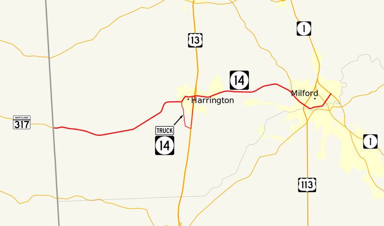 | ||
West end: MD 317 near Burrsville, MD | ||
Delaware Route 14 (DE 14) is a state highway in the southern part of Kent County, Delaware. The route runs from the Maryland border near Burrsville, Maryland, where it continues as Maryland Route 317 (MD 317), east to DE 1 in Milford. The route passes through Harrington, where it intersects U.S. Route 13 (US 13), and passes to the north of Houston before coming to Milford, where it intersects DE 15, US 113, and DE 1 Business (DE 1 Bus.). DE 14 has a truck bypass of Harrington known as DE 14 Truck.
Contents
- Map of DE 14 Delaware USA
- Route description
- History
- Major intersections
- DE 14 Truck
- Former DE 14A
- References
Map of DE-14, Delaware, USA
DE 14 was first designated by 1936 to run from the Maryland border near Burrsville east to DE 26 in Bethany Beach. In 1939, the road was extended south to Fenwick Island. In the 1940s, the road was realigned to bypass Rehoboth Beach. The route between Nassau and Rehoboth Beach was widened into a divided highway in the 1950s, with all of DE 14 southeast of Milford being upgraded to a divided highway by the 1970s. In 1977, most of DE 14 east of Milford was replaced with DE 1, with the eastern terminus being realigned to its current location by 1984.
Route description
DE 14 begins at the Maryland border, where it continues west into that state as MD 317. From the state line, the route heads east on two-lane undivided Vernon Road, passing through a mix of farmland and woodland with occasional homes and crossing Marshyhope Creek. The road curves to the northeast before bending east as Walt Messick Road and entering Harrington. DE 14 runs past homes and some businesses before intersecting DE 14 Truck, which bypasses Harrington to the south. At this point, DE 14 heads northeast on Commerce Street into the downtown area. Here, the route turns east onto Clark Street and crosses Norfolk Southern's Delmarva Secondary railroad line. On the eastern edge of Harrington, DE 14 intersects US 13 in a commercial area, at which point DE 14 Truck returns to the route.
Past this intersection, the route leaves Harrington and becomes Milford Harrington Highway, heading through a mix of farms and woods with some residential development. The road continues east through more rural areas, passing to the north of Houston. Farther east, DE 14 bends southeast and intersects the southern terminus of DE 15, crossing into Milford. The road enters commercial areas and gains a center left-turn lane, coming to an intersection with US 113. Past this intersection, the route becomes Northwest Front Street and runs past homes and businesses a short distance to the north of Norfolk Southern's Indian River Secondary railroad line and Silver Lake along the Mispillion River, narrowing back to two lanes. The road curves to the east, passing to the south of the Parson Thorne Mansion, and heads through the downtown of Milford, becoming Northeast Front Street at the intersection with North Walnut Street. DE 14 passes a short distance to the north of the Mispillion River, curving northeast and coming to an intersection with DE 1 Bus. Past this intersection, the route continues through areas of farmland with some commercial development, ending at an intersection with the DE 1 bypass of Milford.
DE 14 has an annual average daily traffic count ranging from a high of 14,121 vehicles at the western edge of Milford to a low of 1,804 vehicles at the eastern terminus at DE 1. None of DE 14 is part of the National Highway System.
History
What would become DE 14 originally existed as a county road between the Maryland border in Burrsville and Rehoboth Beach by 1920. By 1924, the road was built as a state highway between Burrsville and Milford and was proposed as one between Nassau and Rehoboth Beach. A year later, the state road was completed between Milford and Cedar Creek and from Nassau to just west of Rehoboth Beach, with the sections between Cedar Creek and Nassau and into Rehoboth Beach under proposal. A bascule bridge was constructed over the Lewes and Rehoboth Canal in Rehoboth Beach in 1926. In 1927, the state highway between Milford and Rehoboth Beach was finished with the construction of a bascule bridge over the Broadkill River.
In 1931, a state gravel road was extended from Bethany Beach to the Indian River Inlet along the Atlantic Ocean, providing access to the inlet for recreational purposes. By this time, the county road between Rehoboth Beach and Dewey Beach was paved. In January 1933, bids were made for construction of a gravel road from Dewey Beach south to the Indian River Inlet as well as for a timber bridge across the inlet, connecting with the gravel road between the Indian River Inlet and Bethany Beach. This gravel road would provide a direct connection between Bethany Beach and Rehoboth Beach and would provide better access to the Atlantic coast for recreation. The Ocean Highway between Bethany Beach and Rehoboth Beach was completed in 1933. In fall of that year, the roadway between Bethany Beach and Indian River Inlet was paved, with recommendations to pave the road north from the Indian River Inlet toward Rehoboth Beach. In 1934, the Ocean Highway between the Indian River Inlet and Rehoboth Beach was paved. The same year, recommendations were made to extend the Ocean Highway south from Bethany Beach to Fenwick Island, where it would lead to a Maryland state highway continuing to Ocean City.
DE 14 was designated to run from the Maryland border in Burrsville east to DE 26 in Bethany Beach by 1936. In 1939, a southern extension of DE 14 was built between Bethany Beach and the Maryland border in Fenwick Island as a gravel road. In 1940, a swing bridge opened across the Indian River Inlet. The same year, work began for a bypass of the route between Dewey Beach and west of Rehoboth Beach, which included a bascule bridge over the Lewes and Rehoboth Canal. In 1942, the Rehoboth Beach bypass for DE 14 was completed. In addition, the roadway was paved between Fenwick Island and Bethany Beach by that year. In 1952, a new swing bridge opened across the Indian River Inlet after the previous bridge was destroyed by ice and tides in 1948.
The route was widened into a divided highway between DE 18 (now US 9) in Nassau and Rehoboth Beach in 1954 in order to provide relief to traffic heading to the beaches. Channelized intersections were built at DE 18 and the entrance to Rehoboth Beach. As part of this widening, DE 14 was moved to a new alignment to bypass Wescoats Corner, removing a concurrency with DE 18 (now US 9 Bus.). In 1956, DE 14 was realigned slightly north to its current alignment in Burrsville to meet a new routing of MD 317; the former alignment is now Knife Box Road. In 1965, a new dual bridge was constructed across the Indian River Inlet. By 1966, DE 14A was designated onto the former alignment of DE 14 through Rehoboth Beach. The divided highway portion of DE 14 was extended north to DE 16, which included a bypass of Nassau, and between the Indian River Inlet and South Bethany in 1967. In 1971, the divided Miford Bypass between DE 14 southeast of Milford and US 113 north of Milford was completed. In 1971, a contract was awarded to widen DE 14 to a divided highway between Fenwick Island and South Bethany. This widening project was completed a year later. In 1973, construction was underway to make DE 14 a divided highway from the Milford Bypass to DE 16, which included a bypass of Argos Corner; this was completed in 1974.
In 1974, DE 1 was signed concurrent with DE 14 east of Milford and on the Milford Bypass. In 1977, DE 14 was truncated to the southern terminus of the Milford Bypass southeast of Milford, with DE 1 replacing the route between Fenwick Island and the south end of the Milford Bypass and DE 1 Bus. becoming concurrent with route between the Milford Bypass and Northeast Front Street. As a result of this, DE 14A was renumbered to DE 1A. DE 14 was realigned to follow Northeast Front Street to end at DE 1 on the Milford Bypass by 1984.
Major intersections
The entire route is in Kent County.
DE 14 Truck
Delaware Route 14 Truck (DE 14 Truck) is a truck bypass of DE 14 in Harrington. The route heads south from DE 14 on two-lane undivided Farmington Road, leaving Harrington and heading through farmland. DE 14 Truck turns east onto Tower Hill Road and crosses Norfolk Southern's Delmarva Secondary railroad line before coming to an intersection with US 13. At this point, the truck route turns north to form a concurrency with US 13 on Dupont Highway, a four-lane divided highway. The road heads back into Harrington and runs through commercial areas, passing to the east of the Delaware State Fairgrounds, which is where the Delaware State Fair is held and the Harrington Raceway & Casino and Centre Ice Rink are located. US 13/DE 14 Truck crosses Norfolk Southern's Indian River Secondary, with the median widening to include businesses in it. DE 14 Truck ends at another intersection with DE 14. DE 14 Truck was designated in 2008 following an $8.5 million, year-long project that improved the roads the truck route follows.
The entire route is in Harrington, Kent County.
Former DE 14A
Delaware Route 14A (DE 14A) was the designation of the former alignment of DE 14 through Dewey Beach and Rehoboth Beach. The route began at DE 14 in Dewey Beach and headed north into Rehoboth Beach, where it turned to the west and intersected DE 14 again west of Rehoboth Beach. The route was a former segment of DE 14 that was bypassed by 1942 and received the DE 14A designation by 1966. By 1974, the route would become cosigned with DE 1A, with DE 1A replacing DE 14A in 1977.