
Length 24 km Basin area 196.8 km² | - elevation 3 ft (1 m) Basin area 196.8 km² | |
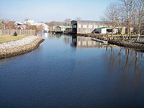 | ||
The Mispillion River is a river flowing to Delaware Bay in southern Delaware in the United States. It is approximately 15 miles (24 km) long and drains an area of 76 square miles (197 km²) on the Atlantic Coastal Plain.
Contents
Map of Mispillion River, Delaware, USA
It rises in northern Sussex County, approximately 3 miles (5 km) southwest of Milford, and flows generally east-northeastwardly, defining the boundary between Sussex and Kent counties; it passes through the center of Milford on its course to its mouth at Delaware Bay, 16 miles (26 km) northwest of Cape Henlopen. The lower 12 miles (19 km) of the river are considered by the U.S. Army Corps of Engineers to be navigable.
A boardwalk known as the Mispillion Riverwalk follows the river in Milford. As of 2003, an effort was underway to preserve a greenway along the river upstream and downstream of Milford.
Variant names and spellingsEdit
According to the Geographic Names Information System, the Mispillion River has also been known historically as: