
Traversed by State Highway 8 Elevation 971 m | Location New Zealand Range Southern Alps | |
 | ||
Road New Zealand State Highway 8 Similar Haast Pass, Lake Dunstan, Southern Alps, Aoraki / Mount Cook, Lewis Pass | ||
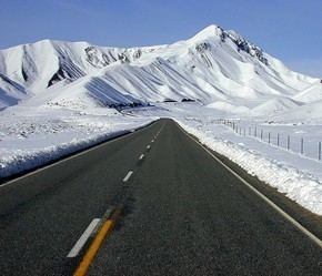
Lindis Pass (elevation 971 m) is located in the South Island of New Zealand.
Map of Lindis Pass, 9382, New Zealand
It lies between the towns of Cromwell in Central Otago and Omarama in North Otago, on the main inland route to the Mackenzie Basin in the Canterbury Region.
The pass lies between the valleys of the Lindis and Ahuriri Rivers.
State Highway 8 transverses the pass on its route from the Mackenzie Basin to Central Otago. The pass is the highest point on the South Island's state highway network, and the second highest point on the New Zealand state highway network, after the Desert Road (SH 1) in the Central North Island. Despite this, it is not considered one of the alpine passes as it located in the dry interior of the South Island.
References
Lindis Pass Wikipedia(Text) CC BY-SA