Country Japan Population 17,980 (Sep 2015) | Region Kantō Area 325.8 km² | |
 | ||
Weather -3°C, Wind SW at 6 km/h, 66% Humidity Points of interest Fukuroda Falls, Morinoide Hot Spring, Eigenji, Namasefuji | ||
Daigo (大子町, Daigo-machi) is a town located in Kuji District, Ibaraki Prefecture, in the northern Kantō region of Japan. As of September 2015, the town had an estimated population of 17,980 and a population density of 55.2 persons per km². Its total area was 325.76 km².
Contents
- Map of Daigo Kuji District Ibaraki Prefecture Japan
- Geography
- Surrounding municipalities
- History
- Education
- Railway
- Highway
- Local attractions
- Noted people
- References
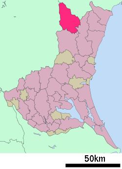
Map of Daigo, Kuji District, Ibaraki Prefecture, Japan
Geography
Located in northwestern Ibaraki Prefecture, Daigo is bordered to the north by Fukushima Prefecture and to the west by Tochigi Prefecture. There are many onsen located in Daigo.
Surrounding municipalities
History
Daigo village was created with the establishment of the municipalities system on April 1, 1889. It was elevated to town status on July 20, 1891. On March 31, 1955, the villages of Yorigami, Fururoda, Miyagawa, Kurosawa, Namase, Kamiogawa, Shimoogawa and Murotono merged with Daigo.
Education
Railway
Highway
Local attractions
Noted people
References
Daigo, Ibaraki Wikipedia(Text) CC BY-SA
