
Traditional Chinese 大明混一圖 | Hanyu Pinyin | |
 | ||
Literal meaning Amalgamated Map of the Great Ming Romanization Dai Ming Gurun-i Uherilehe Nirugan | ||
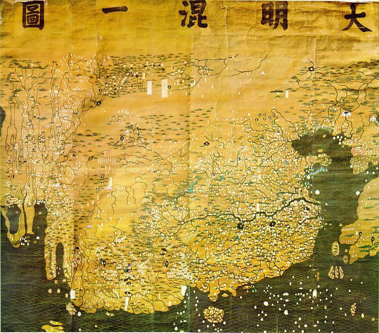
The Da Ming Hunyi Tu (Chinese for the "Composite Map of the Ming Empire") is an extensive Chinese map. It was painted in colour on stiff silk and 386 x 456 cm in size. The original text was written in Classical Chinese, but on the surviving copy Manchu labels were later superimposed. The surviving copy of the map shows later revisions, and it is uncertain whether it is (or how closely it matches) the original.
Contents
It is one of the oldest surviving maps from East Asia although the exact date of creation remains unknown. It depicts Eurasia, placing China in the center and stretching northward to Mongolia, southward to Java, eastward to central Japan, and westward to Europe (including the East African coast as an island).
History
The map was created sometime during the Ming dynasty and handed over to the new rulers of China, the Manchus.
The place names of China on the map reflect the political situation in 1389, or the 22nd year of the reign of the Hongwu Emperor. Thus some Chinese scholars concluded that it was indeed created in 1389 or little later. Others maintain a cautious attitude, suggesting that what was revised in 1389 is probably a source map of the Da Ming Hunyi Tu and that the Da Ming Hunyi Tu itself was created much later.
In either case, it is certain that the Ming dynasty created a map around 1389. Japanese scholar Miya Noriko speculated on the motivation behind it: Although the Hongwu Emperor, first of the Ming dynasty, drove the Mongol Yuan dynasty out of China in 1368, Mongols maintained military power that posed a real threat to the new dynasty. The situation was changed in 1388 when Uskhal Khan of Northern Yuan was killed and the Khubilaid line of succession was terminated. The Ming dynasty may have celebrated this historic event by creating a new map.
It has been kept on the Imperial Palace and was called Qingzi Qian Yitong Tu (清字簽一統圖; "Manchu text-labelled unified map") in some catalogs. It is currently kept in protective storage at the First Historical Archive of China, in Beijing. A full-sized digital replica was made for the South African government in 2002.
Relationship to other maps
Maps had for centuries played an important role in the government of such a vast country, and surviving examples on stone dating from AD 1137 but based on much earlier surveys, show great accuracy, using a grid system. By then the Chinese had also developed the magnetic compass, and in the 13th century western versions of that device allowed European cartography to catch up with Chinese standards of accuracy.
By the early years of the 14th century, when Mongol domination over much of Eurasia created favourable conditions for east-west communication, Islamic maps of Europe and Africa had found its way to China, encouraging Chinese cartographers to create world maps incorporating the new information.
Scholars consider that the Da Ming Hunyi Tu was ultimately based on a now lost world map named Shengjiao Guangbei Tu (聲教廣被圖). It was created by Li Zemin during the Mongol Yuan dynasty. Other extant maps considered to be based on Li's map are some copies of the Kangnido (1402) and a pair of maps named Dongnan Haiyi Tu (東南海夷圖) and Xinan Haiyi Tu (西南海夷圖), which is recorded in the Guang Yu Tu (廣與圖)(1555) by Luo Hongxian (羅洪先). Comparative studies of these extant maps are conducted to restore the content of Li's original world map. The Da Ming Hunyi Tu is especially important because Luo's copies dropped most place names except for coastal areas and islands and because the Kangnido was influenced by Korean cartography.
Compared to the Kangnido, the Da Ming Hunyi Tu provides more detailed information on Mongolia and Central Asia and India. In Manchuria, Changbai Mountain, where the foundation myth of the Manchu Aisin Gioro imperial family was set, is overly portrayed. It presents India as a peninsula while it sinks into the "Chinese continent" on the Kangnido. It is presumed that India was portrayed as a peninsula on Li's map but shrunk by Korean Confucians due to their anti-Buddhist policy. Africa and Arabia on the Da Ming Hunyi Tu resemble those on the Kangnido while Europe is considerably different. It is also distinct from the Kangnido in the depiction of the source of the Yellow River, which looks very similar to that in Luo's Guang Yu Tu.
Content
The Earth's curvature affects even the scale of the Chinese section of the map. Horizontally, it works out at about 1:820,000; but vertically it is around 1:1,060,000. The use of colour is particularly effective within China itself, including elegant touches like the ochre tint of the Yellow River.
It replicates the curvature of the Earth by compression of areas farthest away from China (most obviously the extreme horizontal squeeze of Europe), their reduced size making both a geographical and a political statement. Outside China, sub-Saharan Africa is depicted in a good approximation of the correct shape, complete with mountains near the southern tip. The interior of the continent is extraordinary: a river with twin sources (the common depiction in Classical and Islamic maps of the Nile) starts in the south of the continent, but enters the Red Sea, while the Nile, contrary to the information in non-Chinese maps of the era (though in conformity with a reported Arab geographical legend that "farther south from the Sahara Desert is a great lake, far greater than the Caspian Sea") has its source in a vast inland sea. This is likely to be based on vague information about the several great lakes in the region of modern Tanzania, gained during the course of direct trade between China and south-east Africa.
The European coverage goes only as far as the new portolan mapping, showing the Mediterranean and Black Sea areas. Unlike the African lake, those seas are not shaded with wave symbols, and nor is the nearby Caspian Sea, mapped in Islamic style with two islands, suggesting that the whole area is based on a single Islamic map. Arabia is squeezed horizontally, but recognisable. The prominent peninsula on the west coast of the Chinese landmass is Malaysia, but India is represented merely as a collection of place-names north-west of Arabia. Another manifestation of the same problem, dependence on external sources for geographical information, can be seen to the south of Korea, at the far right side of the map, where Japan, over-sized and misshapen, confusingly meets the much more correctly sized and positioned Taiwan.