
Type glacial lake Max. length 700 m (2,300 ft) Surface area 0.13 km (0.050 sq mi) | Max. width 225 m (738 ft) Surface elevation 2,270 m | |
 | ||
Primary outflows Dösenbach to Mallnitzbach and Möll river | ||
Dösener See is an alpine lake of Carinthia, Austria. It is part of the High Tauern National Park.
Contents
Map of D%C3%B6sener See, 9822 Mallnitz, Austria
Geography
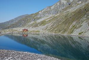
The lake is situated at 2270 metres above the Adriatic (7,450 ft) in the Ankogel Group of the High Tauern range, part of the Central Eastern Alps. It marks the head of the narrow Dösen Valley, stretching about 7 km (4.3 mi) up from Mallnitz in the west. With a surface area of 0.13 km2 (0.050 sq mi), it is the largest cirque lake of the national park area.
Even in summer, the surface temperature never exceeds 7 °C (45 °F); the lake is covered by ice up to three quarters of a year. The water transparency comes to about 12 m (39 ft). In Dösener See, Arctic char are found as well as plankton species like rotifer and green algae.
The Arthur-von-Schmid-Haus, an Alpine club hut erected in 1910-11, stands on the western shore. From here, mountain trails lead to neighbouring summits such as the Hochalmspitze and the Reisseck massif. A large rock glacier (Blockgletscher) is located east of Dösener See, with a permafrost depth of up to 40 metres (130 ft).