
Elevation 1,702 m (5,584 ft) | ||
 | ||
Similar Mont Aigoual, Mont Lozère, Gardon, Gorges du Tarn, Pic Saint‑Loup | ||
C vennes echapp es belles
The Cévennes (Occitan: Cevenas) are a range of mountains in south-central France, covering parts of the départements of Ardèche, Gard, Hérault and Lozère.
Contents
- C vennes echapp es belles
- Map of CC3A9vennes 48220 Fraissinet de LozC3A8re France
- Le parc national des c vennes
- Extent
- Description
- Geology
- Population and history
- Transport
- By car
- Tourism
- References
Map of C%C3%A9vennes, 48220 Fraissinet-de-Loz%C3%A8re, France
The word Cévennes comes from the Gaulish Cebenna, which was Latinized by Julius Caesar to Cevenna. The Cévennes are named Cemmenon (Κέμμενων) in Strabo's Geographica.
In French, the adjective derived from "Cévennes" is Cévenol (fem. Cévenole), as in d'Indy's Symphonie Cévenole, a composer of Ardèche origin (known in English as his Symphony on a French Mountain Air).
The mountain range also gives its name to a meteorological effect when cold air from the Atlantic coast meets warm air of southern winds from the Mediterranean and causes heavy autumnal downpours, often leading to floods. These are called épisodes cévenols.
Le parc national des c vennes
Extent
In the larger sense, the Cevennes include 9 départements : le Tarn, l'Aude, l'Hérault, l'Aveyron, le Gard, la Lozère, l'Ardèche, le Rhône et la Loire. More strictly the Cevennes encompasses the Lozère and the Gard. The Parc national des Cévennes is almost entirely within Lozère.
The principal towns and villages of the Cevennes are Alès, Le Vigan, Sumène, Valleraugue, Ganges, Saint-Hippolyte-du-Fort, Sauve, Lasalle, Saint-André-de-Valborgne, Saint-Jean-du-Gard, Anduze, Florac, Saint-Germain-de-Calberte, le Pont-de-Montvert, Villefort, Génolhac, Bessèges, Saint-Ambroix, Gagnières, Les Vans, Mende.
Description
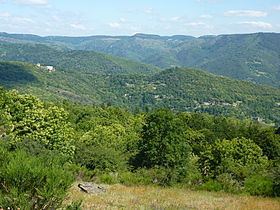
The Cévennes are on the south-eastern flank of the Massif Central. They run from southwest (Cause Noire) to northeast (Monts du Vivarais), with the highest point being the Mont Lozère (1702m). The Mont Aigoual (1567m) is on the border of the two department. The Loire and Allier flowing towards the Atlantic ocean, as well as the Ardèche and tributary Chassezac, Cèze, the different Gardons to the Rhône, Vidourle, Hérault and Dourbie rivers that flow to the Mediterranean Sea, have their headwaters in the Cévennes. Cévennes National Park was created in the region in 1970 and the Parc Naturel Régional des Monts d'Ardèche also preserves some of the natural areas. Two canyons are near the region: the Gorges de la Jonte (the Jonte River gorge) and the Gorges du Tarn (the Tarn River gorge). This is a socio-economic marginal region, while bio-geographically, there is altitudinal stratification and a gradient between the mountainous centre and the mediterranean littoral ecologies.
Geology
The Cévennes form the south eastern fragment of the Massif Central, separated from the related Montagnes Noires by the limestone Causses. The basement rocks of Granites and Schistes were uplifted by the Variscan Orogeny forming a discontinuity, with the subsequent erosion infilling the lower voids for much of Permian and Triassic period (280 - 195 Ma), while changing sea levels added a thick limestone covering, with only the tops of the Cévennes protruding as islands in the Jurassic sea. This in turn was eroded, The Cévennes forms the watershed between the Atlantic and Mediterranean. In late Cretaceous and early Tertiary times further mountain building occurred. The Alpine orogeny lifted and deformed the Alps and the Pyrenees though the Massif Central acted as a rigid block, and the cover rocks remained mostly horizontal. Some have been folded through later faulting at the time of the opening of the western Mediterranean in Tertiary times. The principal rivers of the region have cut deeply into the limestone forming deep gorges: Gorges du Tarn, Gorges de la Jonte, Lot, Gorges de l'Ardèche, Cèze etc.
Population and history
In the 21st century, the region still has a large community of French Protestants. They identify as Huguenots, descendants of peoples who have inhabited the mountains since before the 16th century. During the reign of Louis XIV, much of the Huguenot population fled France, particularly following the revocation of the Edict of Nantes in 1685. The Protestant community in the Cévennes largely remained in place, protected from attack by the hilly terrain. This area became a refuge from persecution for other Huguenots during the time.
In 1702, this Huguenot population, dubbed the Camisards, rose up against the monarchy to protect their religious freedom. The two sides agreed to peace in 1715, which enabled the local Protestant Huguenot population to continue living in the Cévennes. Their descendants have continued to live there to the present day.
Transport
3-hour TGV from Paris, 1h30 flight from London (Luton) to Nimes (Garons), the closest international airport and 2h30 drive from Barcelona.