
Basin size 2,430 km (940 sq mi) Discharge 65 m³/s | Length 125 km Basin area 2,430 km² | |
 | ||
Progression Rhône→ Mediterranean Sea | ||
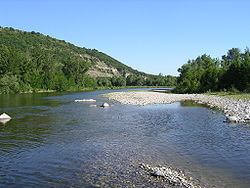
The Ardèche (Occitan: Ardecha) is a 125-kilometre (78 mi) long river in south-central France, a right-bank tributary of the River Rhône. Its source is in the Massif Central, near the village of Astet. It flows into the Rhône near Pont-Saint-Esprit, north-west of Orange. The river gives its name to the French department of Ardèche.
Contents
- Map of ArdC3A8che France
- GeographyEdit
- Towns and communesEdit
- TributariesEdit
- HydrologyEdit
- Rates of flow at Saint Martin dArdcheEdit
- Voice serverEdit
- PeculiarityEdit
- HydronymyEdit
- Protected areasEdit
- Tourist attractionsEdit
- References
Map of Ard%C3%A8che, France
The valley of the Ardèche is very scenic, in particular a 30-kilometre (19 mi) section known as the Ardèche Gorges. The walls of the river here are limestone cliffs up to 300 metres (980 ft) high. A kayak and camping trip down the gorge is not technically difficult and is very popular in the summer. The most famous feature is a natural 60-metre (200 ft) stone arch spanning the river known as the Pont d'Arc (arch bridge).
GeographyEdit
The source of the river lies at 1,467 metres (4,813 ft) above sea level in the Vivarais, near the Col de la Chavade, in the forest of Mazan in the commune of Astet. After the towns of Aubenas and Ruoms, it collects the Chassezac and the Beaume river, subsequently plunging into its famous gorge below Vallon-Pont-d’Arc. It flows into the Rhône (river) at Pont-Saint-Esprit.
Towns and communesEdit
The Ardèche flows through the following departments and communes:
TributariesEdit
The most important tributaries and subtributaries to the Ardèche River include:
HydrologyEdit
The river has an average discharge of 65 cubic metres per second (2,300 cu ft/s) but experiences severe floods, called "coups de l'Ardèche" (Blows of the Ardèche), in spring and autumn and periods of very low water in summer. During flood events in 1827, 1890, and 1924, it reached 7,800 cubic metres per second (280,000 cu ft/s) and the water level rose to a record 21.4 metres (70 ft) in the gorge.
Despite the Ardèche's short length, the flow of the river at 65 cubic metres per second (2,300 cu ft/s) is relatively high—higher than the Gardon at 32 cubic metres per second (1,100 cu ft/s), the Cèze (22 m3/s), the Hérault (44 m3/s), or the Agout (55 m3/s)—major rivers south of the Massif Central but much longer.
Rates of flow at Saint-Martin d'ArdècheEdit
The inter-annual average flow of the Ardèche was observed and calculated over a period of 26 years at Saint-Martin d'Ardèche. It amounted to 63.4 cubic metres per second (2,240 cu ft/s) for a surface basin of 2,240 square kilometres (860 sq mi)—i.e. the vast majority of its watershed of 2,430 square kilometres (940 sq mi). The river has seasonal fluctuations: a typical flow around the Cevennes, with high water in autumn and winter being double the normal, brings the average monthly flow at the first peak of 93 cubic metres per second (3,300 cu ft/s) in October then, after falling to 76 cubic metres per second (2,700 cu ft/s) in December, a new peak occurs from 96 to 102 cubic metres per second (3,400 to 3,600 cu ft/s) in January–March (with a maximum in January). A rapid decline in flow rate follows ending in a dry period in July–August resulting in a decrease of the average monthly rate to the level of 12 cubic metres per second (420 cu ft/s) in July. (See bar chart below.)
The VCN3 (minimum flow) can drop to 2.5 cubic metres per second (88 cu ft/s) in a dry year.
Floods can be extremely important (usually following storms in the Cevennes). The Qix 2 and Qix 5 are respectively 1,800 and 2,600 cubic metres per second (64,000 and 92,000 cu ft/s) which is high. QIX 10 is 3,100 cubic metres per second (110,000 cu ft/s) while QIX 20 and QIX 50 respectively rise to 3,600 and 4,300 cubic metres per second (130,000 and 150,000 cu ft/s).
The maximum instantaneous flow recorded in Saint-Martin d'Ardèche has been 4,500 cubic metres per second (160,000 cu ft/s) (two-thirds of the average flow of the Danube), while the maximum recorded daily rate was 2,506 cubic metres per second (88,500 cu ft/s).
The runoff curve number flowing into the catchment of the river is 897 millimetres (35.3 in) annually, which is very high. The specific flow (Qs) reaches 28.3 litres per second per square kilometre of the catchment.
Voice serverEdit
The prefecture of Ardèche has provided a voice server since June 2005 whose objective is to regularly disseminate information messages to allow monitoring of any significant event that might trigger a civil security crisis or standby alert. Precise information on the evolution of any flood is provided.
PeculiarityEdit
The Ardèche receives water from the Loire river via the "La Palisse" flood barrier and the Lake d'Issarlès. Effectively, the water is collected to feed the EDF hydroelectric plant at Montpezat-sous-Bauzon and is subsequently piped into the Fontaulière river, a tributary of the Ardèche, near the town of Aubenas.
HydronymyEdit
Several ancient inscriptions about a college of nautes (Boatmen) in associated rivers have been discovered in the Gard. It is possible that the two rivers concerned are the Ardèche and the Ouvèze.
The identification of these two rivers is still pending. However, if it does involve the Ardèche river, the spellings Hentica (from 950), then Ardesca (in the Charta Vetus) have been attested.
Protected areasEdit
The Ardèche is protected along almost all of its course. These protected areas are:
Tourist attractionsEdit
The Gorges de l’Ardèche (Ardèche Gorge) is located between the villages of Vallon-Pont-d'Arc and Saint-Martin-d'Ardèche. The road along the north rim of the gorge (the Corniche) offers spectacular views into the gorge and over the river.
A natural stone bridge across the river near the town of Vallon-Pont-d'Arc forms the natural to the Gorges de l'Ardèche.
This limestone cave, which is named after its discoverer, is in the Gorges de l'Ardèche. It contains early Stone Age cave paintings of great variety and expressiveness. Since the cave is not open to the public, photographs of cave paintings are displayed in an exhibition in Vallon-Pont d'Arc.