
Formed January 29, 2010 Fatalities 1 direct | Dissipated February 8, 2010 Damage $70 million (2010 USD) | |
 | ||
Highest winds 10-minute sustained: 185 km/h (115 mph)1-minute sustained: 215 km/h (130 mph) Lowest pressure 925 hPa (mbar); 27.32 inHg Date 29 January 2010 – 8 February 2010 Similar Cyclone Wasa–Arthur, Cyclone Osea, Cyclone Tia, Cyclone Trina, Cyclone Tomas | ||
Severe tropical cyclone oli 12p february 02 04 2010
Severe Tropical Cyclone Oli (RSMC Nadi designation 07F, JTWC designation 12P) was the first severe tropical cyclone within the South Pacific basin since Cyclone Gene in 2008.
Contents
- Severe tropical cyclone oli 12p february 02 04 2010
- Severe tropical cyclone oli
- Meteorological history
- Cook Islands
- Tahiti
- French Polynesia
- References
At least one person was killed by large swells produced by the storm in French Polynesia.
Severe tropical cyclone oli
Meteorological history
Severe Tropical Cyclone Oli was first identified by the Fiji Meteorological Service (FMS) early on January 29. In their first advisory on the system, the FMS designated the system as Tropical Disturbance 07F and centered roughly 700 km, (430 mi) north-west of Suva, Fiji. The following day, the Joint Typhoon Warning Center (JTWC) began monitoring the disturbance as an area of mid-level convection. Satellite imagery depicted a developing low-level circulation center within the system as it moved within a region of moderate wind shear. Later on January 30, convective banding features developed along the periphery of the system as it moved eastward in response to a subtropical ridge to the north. Around 0900 UTC on January 31, the FMS upgraded the disturbance to a tropical depression. Shortly thereafter, the JTWC issued a Tropical Cyclone Formation Alert (TCFA) on the system, stating that the system was likely to develop into a tropical storm within 24 to 48 hours. Early the next day, the JTWC declared that the depression had intensified into a tropical storm and classified it as Tropical Cyclone 12P.
Cook Islands
Late on January 31, RSMC Nadi placed the islands of Pukapuka, Nassau and Suwarrow under a tropical cyclone alert, whilst a strong wind warning was put in place for the rest of the northern Cook Islands. Early the next day, RSMC Nadi cancelled the alert for Pukapuka and Nassau, whilst placing Suwarrow island under a tropical cyclone warning. However the warning was cancelled later that day, after Oli had moved away.
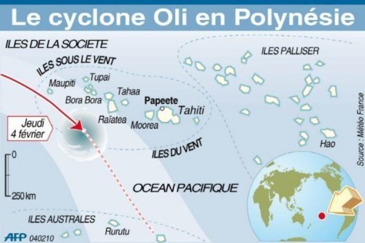
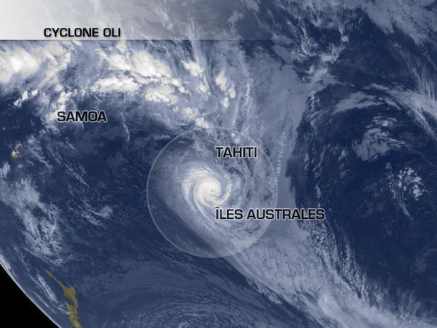
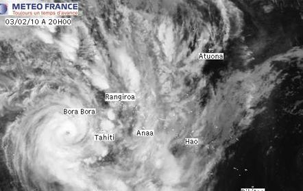
Tahiti
Prior to Oli's arrival, roughly 3,400 people were evacuated from low-lying, coastal areas in Tahiti and the surrounding islands. As the storm bypassed Tahiti and nearby islands on February 4 and 5, the local government declared a red alert as winds up to 195 km/h (120 mph) impacted the region. Numerous structures were damaged across the islands and several people were injured. Numerous power and telephone lines were knocked out, hampering communication on the affected islands.
French Polynesia
After tracking by Tahiti, Oli turned southward and threatened the islands of French Polynesia. Officials quickly began urging people to evacuate to designated shelters and remain indoors. All flights were cancelled to and from the area as well as all seafaring vessels. All schools were closed prior to Oli's arrival. About 650 tourists were trapped on Bora Bora Island after transportation throughout the region was shut down. An estimated 4,000 residents on the islands evacuated to public shelters by February 4.
Cook Islands
Minor damages were reported within the Cook Islands after they were affected by heavy rain, high seas and strong winds. On Penrhyn and Pukapuka island heavy rain caused houses and roads to be flooded, whilst on Omoka island, wharfs were reported to have been damaged.
Tahiti
Numerous structures were damaged across the islands and several people were injured. Numerous power and telephone lines were knocked out, hampering communication on the affected islands. Major damage was reported in Papenoo.
Shortly after the storm passed, power companies deployed crews to restore power to the island. By 9:30 am (local time) on February 5, roughly 20% of the island's homes remained without power.
French Polynesia
At least one person was killed by large swells produced by the storm around the island of Tubuai in the Austral islands, south of Tahiti. Hundreds of homes were damaged across the islands as strong winds, recorded up to 200 km/h (120 mph) battered them. The winds also downed power and telephone lines and led to officials banning road travel. Winds up to 120 km/h (75 mph) impacted Bora Bora Island during the storm's passage. A total of 40 homes were destroyed on the island and one person was seriously injured.
On the island of Tubuai alone, 200 homes sustained damage from the storm, leaving more than $11 million (USD) in monetary losses. Elsewhere in the region, the storm left an additional $13 million in damage.
Following the widespread damage from the storm, the local government declared a state of natural calamity. Additionally, the overseas minister of France pledged to establish a relief fund for victims of the storm.