
Formed March 4, 1992 Fatalities 5 direct | Dissipated March 17, 1992 | |
 | ||
Highest winds 10-minute sustained: 205 km/h (125 mph)1-minute sustained: 260 km/h (160 mph) Lowest pressure 920 hPa (mbar); 27.17 inHg Damage $9.4 million (1992 USD) Date 4 March 1992 – 17 March 1992 Similar Cyclone Esau, Cyclone Tia, Cyclone Sose, Cyclone Betsy, Cyclone Susan | ||
Severe Tropical Cyclone Fran was the third tropical cyclone within four weeks to impact Vanuatu in 1992. Fran formed on March 4 and then gradually intensified. Winds reached gale-force on March 5, and hurricane-force a few days later. Cyclone Fran reached the powerful Category 5 equivalent on the Saffir–Simpson Hurricane Scale near Vanuatu. The storm weakened somewhat due to land interaction, but briefly re-intensified after moving away from land. Fran gradually weakened over the next several days over less favorable conditions. Meanwhile, the storm passed north of New Caledonia. Eventually, as a Category 2 system on the Australian scale, Fran made landfall on Queensland during March 16. Severe Tropical Cyclone Fran turned towards the southeast and eventually headed back out to sea. The system dissipated the next day. On Efate, over 130 houses lost roofs. Along Queensland, two rivers sustained major flooding, but no deaths were attributed to this cyclone. Total damage from the system was 8-10 million (1992 AUD). Moderate damage was also reported in Fiji. In New Caledonia, the storm brought flooding and landslides.
Contents
Meteorological history
On March 4, the Fiji Meteorological Service's Nadi tropical cyclone warning centre (TCWC Nadi) started to monitor, a shallow tropical depression that had developed within the monsoon trough to the north-northwest of the Samoan Islands.
Over the next two days the depression slowly developed further as it moved towards the south-southwest, before the system was named Fran early on March 6 by TCWC Nadi as the system had started to rapidly intensify and had become a category 1 tropical cyclone on the Australian tropical cyclone intensity scale and started to rapidly intensify. The NWOC also designated Fran as Tropical Cyclone 25P and started to issue advisories on it during that day as it passed about 75 km (45 mi) to the north of Futuna Island. During that day as the system continued to move towards the south-southwest it crossed the International Dateline, which prompted the NWOC to pass the responsibility for warning the United States Government to the Joint Typhoon Warning Center.
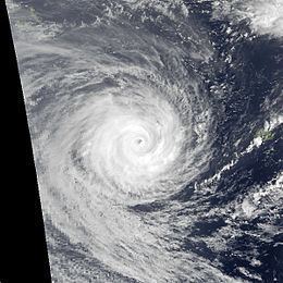
Early on March 7 as Fran passed about 400 km (250 mi) to the north of Suva, Fiji, TCWC Nadi reported that Fran had intensified into a category 3 severe tropical cyclone on the Australian scale. Over the next day the system steadily intensified further as it moved towards Vanuatu, before the JTWC reported at 1800 UTC on March 8 that Fran had peaked with 1-minute sustained wind speeds of 260 km/h (160 mph) which made it equivalent to a category 5 hurricane on the SSHS. At around the same time TCWC Nadi estimated that Fran had peaked with 10-minute sustained wind speeds of 100 knots, which made it a category 4 severe tropical cyclone on the Australian scale. Over the next 18 hours the system moved in-between the Vanuatuan Islands of Shefa and Erromango and passed about 50 mi (80 km) to the south of Port Vila, as it started to gradually weaken.
After weakening slightly because of land interaction, the cyclone slowly re-intensified as it pulled away from the island. Cyclone Fran passed north of New Caledonia early March 10, with 1-min sustained winds of 200 km/h (125 mph). Subsequently, Fran moved towards the west and attained its secondary 10-minute sustained peak of 145 km/h (90 mph) and 1-minute sustained peak of 175 km/h (110 mph) on March 12. The cyclone had slowed by this stage and it subsequently assumed a somewhat erratic southwest track towards the coast. Over the subsequent next three days, Fran weakened as it became less organized. The cyclone finally crossed the Queensland coast (becoming the second cyclone of the season to do so) near the town of 1770 on 1700 UTC March 15. About an hour after landfall, the NWOC reported that the storm had 1-minute sustained winds of 45 mph (72 km/h). Fran subsequently moved inland and weakened to a tropical depression before re-curving to the southeast and moving back over water. The remnants of Fran tracked over Norfolk Island before ultimately merging with a trough north of New Zealand.
Preparations and impact
Fran effects were felt over a large area of the Southern Pacific as it impacted the island nations of Wallis and Futuna, Fiji, Vanuatu, New Caledonia and Australia. The system caused extensive damage to the islands and was responsible for 5 deaths, while the name Fran was subsequently retired from the list of tropical cyclone names for the Southern Pacific. The French territory of Wallis and Futuna was impacted between March 5 – 8 and was the first island nation to be impacted by the system. On March 6 a wind gust of 112 km/h (70 mph) was recorded in Hihifo, while rainfall totals of 556.7 mm (21.92 in) and 525 mm (20.7 in) were recorded in Hihifo and Mont Holo during March 5. Fran brought down roofs, trees, telephones and power lines while several boats were sunk. Fiji was the second island nation to be affected by the system, however, the damage was not formally assessed and the system was estimated to have caused a minor-moderate amount of damage.
After affecting both Fiji and Wallis and Futuna, Fran posed a major threat to parts of Vanuatu, as it became the fourth of five tropical cyclones to affect the island nation during the 1991-92 season. Ahead of the system impacting the island nation between March 8–10, schools were closed and several evacuation centres were opened, while communication equipment was secured and the National Disaster Management office broadcast hourly warnings. During March 9 the system passed about 25 km (15 mi) to the north of Erromango and about 80 km (50 mi) to the south of the island of Efate as a category 5 severe tropical cyclone. Erromango was estimated to have experienced hurricane-force winds of 130 km/h (81 mph), while storm force winds of 56 km/h (35 mph) and wind gusts of 146 km/h (91 mph) were experienced at Bauerfield on Efate. On the island of Efate damage was widespread but variable, with places that were exposed to the south and west worst hit, including the village of Pango located just outside Port Vila. The roofs of 130 homes were destroyed and as a result suffered water damage, including on the Parliamentary complex of buildings. Port Vila was without electricity and fresh water supply for several days, while there was major damage reported to several buildings. Roads were blocked and On Erromango considerable damage to crops was reported while several homes were damaged. It was thought by the Vanuatu Meteorological Service that if Fran had passed about 30 km (20 mi) to the north, then the situation would have been a lot worse.
As the system affected Vanautu
In New Caledonia, flooding and mudslides occurred. Winds of 220 km/h (140 mph) were measured on Poum. The highest rainfall total was 237 mm (9.3 in) on Tango Dzumac. A total of 150 boxes were damaged or destroyed.
Floods affected Southern Queensland and some 17 houses were unroofed near Bundaberg.
On Heron Island, a small island off the Australian coast, winds of 45 mph (72 km/h) were reported, 60 mm (2.4 in) of rain fell in a day, and a storm surge of 0.8 ft (0.24 m) was estimated. Considerable damage to the trees were reported and many birds were killed, but no damage from buildings were reported. One Casuarina was lost during the cyclone. Significant erosion and loss of materials were reported. The cyclone continued the process of removing fine material from the top of the island. Despite significant beach erosion, there were no significant accumulation of fines on the reef and thus there were no harmful impacts to the flora and fauna on the coral reef.
In Australia, officials closed beaches along the Sunshine and Gold Coasts. In addition, train services from Brisbane were cancelled.
Several roofs were torn off of homes and some flooding was reported. Winds and flooding caused minor property damage, but considerable crop losses along were reported the coast, with the worst effects in Bundaberg. A total of 40 houses were uproofed throughout Bundaberg. In Burnett Heads, 3 yachts were damaged. Heavy swells caused damage on Heron Island and severe erosion on the Gold and Sunshine Coasts. Overall, 2,624 insurance claims were made because of property damage. Total damage from the system was 8–10 million (1992 AUD), while insurance losses were estimated at $2.5 million (1992 AUD).
In preparation of the storm, officials closed beaches along the Sunshine and Gold Coasts. In addition, train services from Brisbane were cancelled. Across Queensland, coastal towns were flooded, uprooting trees and knocking out power. Several roofs were torn off of homes and some flooding was reported. Winds and flooding caused minor property damage, but considerable crop losses along were reported the coast, with the worst effects in Bundaberg. A total of 40 houses were uproofed throughout Bundaberg. In Burnett Heads, 3 yachts were damaged. Heavy swells caused damage on Heron Island and severe erosion on the Gold and Sunshine Coasts. Overall, 2,624 insurance claims were made because of property damage. Total damage from the system was 8-10 million (1992 AUD), while insurance losses were estimated at $2.5 million (1992 AUD).