
Elevation 550 m | OS grid SO262226 Parent range Black Mountains, Wales | |
 | ||
Similar Pen Allt‑mawr, Pen Cerrig‑calch, Pen y Gadair Fawr, Waun Fach, Mynydd Llysiau | ||
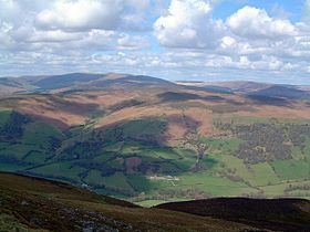
Crug Mawr is a hill in the Black Mountains in the Brecon Beacons National Park in southern Powys, Wales. Its summit at a height of 550m (1,805 ft) is marked by a trig point. The peak sits high above the valleys of the Grwyne Fawr and Grwyne Fechan to the north of the more well-known Sugar Loaf. The views from here across the Black Mountains are wide ranging and also extend eastwards across Monmouthshire. Four ridges run off to the northwest, east, southeast and southwest, the last ending in the subsidiary summit of Blaen-yr-henbant.
Contents
Map of Crug Mawr, Abergavenny, UK
AccessEdit
All of the upper slopes of the hill are designated as open country. A bridleway runs up from the minor road east of Llanbedr and then on northwards to Mynydd Du Forest. The Beacons Way runs across the slopes of the hill between Partrishow and Llanbedr.
GeologyEdit
In common with other hills in the Black Mountains, Crug Mawr is formed from mudstones and sandstones of the Old Red Sandstone laid down during the Devonian period but there is little rock exposed at the surface other than in the beds of the streams which occupy valleys such as Cwm Milaid and Cwm Beusych.