
Population 2,262 (2011 census) Post town BLAIRGOWRIE Local time Tuesday 12:20 PM | OS grid reference NO222401 Sovereign state United Kingdom Postcode district PH13 Dialling code 01828 | |
 | ||
Weather 8°C, Wind SW at 14 km/h, 67% Humidity UK parliament constituency Perth and North Perthshire | ||
Fireworks display coupar angus perthshire scotland
Coupar Angus /ˈkʊ.pərˈæŋ.əs/ (Gaelic: Cùbar Aonghais) is a town in Perth and Kinross, Scotland, situated four miles south of Blairgowrie.
Contents
- Fireworks display coupar angus perthshire scotland
- Map of Coupar Angus Blairgowrie UK
- Motorcycle charity run coupar angus perthshire scotland
- Coupar Angus Abbey
- National Library of Scotland
- Polish Forces
- Scottish Fold
- Sport
- Astronomy
- Emigrants
- References
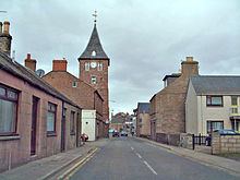
Map of Coupar Angus, Blairgowrie, UK
The name Coupar Angus serves to differentiate the town from Cupar, Fife. The town was transferred from the county of Angus to Perthshire in 1891, but retained its traditional name.
It is located on the A94 Perth-Forfar road, although the town centre itself is now bypassed.
Motorcycle charity run coupar angus perthshire scotland
Coupar Angus Abbey
In the Middle Ages it was the site of the major Cistercian abbey of Coupar Angus, one of Scotland's most important monasteries, founded by Malcolm IV (1153–65) in the 1160s. Of the abbey, only architectural fragments, preserved in the 19th-century parish church (which is probably on the site of the monastic church), or built into houses and walls throughout the town, survive, along with part of one of its gatehouses.
National Library of Scotland
The National Library of Scotland provides access to several historical maps that make reference to Coupar Angus. [1]
Polish Forces
Several Polish units were stationed in and around Coupar Angus from 1939 to 1945. [5]