Suvarna Garge (Editor)

County of Wonnangatta

Updated on
Edit
Like
Comment
Share on FacebookTweet on TwitterShare on LinkedInShare on Reddit
Established
  
24 February 1871

Area
  
5,760 kmĀ²

Wonnangatta
  
Dargo

Founded
  
24 February 1871

County of Wonnangatta

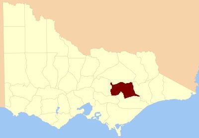
The County of Wonnangatta is one of the 37 counties of Victoria which are part of the cadastral divisions of Australia, used for land titles. It includes the western parts of the Alpine National Park. The Wonnangatta River is located in the east of the county. Lake Eildon is at the northwestern edge. Mount Buller is on the northern edge.

Parishes

Parishes include:

  • Billabong, Victoria
  • Bolaira, Victoria
  • Boorolite, Victoria
  • Buckenderra, Victoria
  • Budgee Budgee, Victoria
  • Buragwonduc, Victoria
  • Changue, Victoria
  • Cobbannah, Victoria
  • Crookayan, Victoria
  • Darlingford, Victoria
  • Doledrook, Victoria
  • Enoch's Point, Victoria
  • Goulburn, Victoria
  • Howqua, Victoria
  • Howqua West, Victoria
  • Jamieson, Victoria
  • Kevington, Victoria
  • Knockwood, Victoria
  • Kybeyan, Victoria
  • Lauraville, Victoria
  • Licola, Victoria
  • Lodge Park, Victoria
  • Matlock, Victoria
  • Miowera, Victoria
  • Moroka, Victoria
  • Narbourac, Victoria
  • St.Clair, Victoria
  • Tamboritha, Victoria
  • Taponga, Victoria
  • Tarldarn, Victoria
  • Torbreck, Victoria
  • Warrambat, Victoria
  • Wonnangatta, Victoria
  • Youarrabuk, Victoria
  • References

    County of Wonnangatta Wikipedia