
Length 41.49 km | ||
 | ||
Counties | ||
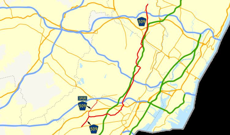
County Route 509, abbreviated CR 509, is a county highway in the U.S. state of New Jersey. The highway extends 25.78 miles (41.49 kilometers) from North Avenue (Route 28) in Westfield to Straight Street (CR 504) in Paterson.
Contents
Map of Co Rd 509, Silex, MO 63377, USA
For two small stretches – in Clifton at the interchange with Route 19, and in Paterson as it crosses over the Passaic River – CR 509 splits into separate northbound and southbound alignments.
CR 509 intersects with the Garden State Parkway at Exit 138 in Kenilworth.
Route description
CR 509 begins at a complex interchange in the town of Westfield, seven miles (11 km) west of Elizabeth. State Route 28 (South Ave.) and Union County Route 610 (North Ave.) come from Scotch Plains to the west on either side of the train tracks running along New Jersey Transit's Raritan Valley Line and criss-cross at a traffic circle a few hundred feet from the Westfield Train Station. CR 509 (East Broad Street) branches off in a northeast direction from Route 28 just after the state highway branches off of the circle and crosses under the tracks before continuing east.
After cutting through downtown Westfield, CR 509 passes Fairview Cemetery on the right before coming to an intersection with CR 577 (Springfield Avenue), which splits off to the left before banking due north toward Mountainside, Springfield and U.S. Route 22 (US 22). CR 509 turns right onto Springfield Avenue but quickly becomes Kenilworth Boulevard. For less than a mile, the route passes through Cranford, during which time County Route 615 splits off to the right. It crosses into Kenilworth, where it is signed simply as "Boulevard" while traveling nearly due east. (East Broad Street continues straight as Nomahegan Drive for less than a mile before coming to a dead end).
Once through downtown Kenilworth, CR 509 interchanges the Garden State Parkway at Exit 138 before crossing into Union. It dips southeast for a few hundred feet, then turns left onto Salem Road at a five-point intersection with Union County routes 616 (Galloping Hill Road, bound for Roselle Park) and 619 (Chesnut Street, running between Linden and Irvington in Essex County).
Salem Road slowly bends back to the north, crossing State Route 82 near Kean University and over the Elizabeth River into Hillside, where it passes Vaux Hall Road and Hillside High School. CR 509 passes under US 22, but has no interchange. Traffic looking to access US 22 must turn right just beyond the overpass at Hillside Avenue, where access is provided near the Newark border. CR 509 turns left onto Hillside Avenue, while the road (now Liberty Road) continues to a dead end at St. Peter's Park on the outskirts of Newark.
After turning, CR 509 makes another quick turn, this time onto Chestnut Avenue. It passes over Interstate 78 (again with no interchange), to which access is available via Paine Avenue. The route continues as Coit Street, then Grove Street as it moves into Irvington and Essex County.
Now in a heavily populated neighborhood, CR 509 crosses Springfield Avenue a little east of the end of the State Route 124 designation, and crosses several 600-series routes while closely paralleling the Parkway. It intersects CR 510 (South Orange Avenue) at the massive Cemetery of the Holy Sepulchre, then moves into Newark for about half a mile, then enters East Orange where it meets CR 508 (Central Avenue). Shortly thereafter, it interchanges with Interstate 280, providing access to Newark, the Oranges and the Parkway.
CR 509 continues north into Bloomfield, where it turns left onto Franklin Street. It crosses back under the Garden State Parkway before moving into Passiac County, through the cities of Clifton and Paterson, where it ends at CR 504.
CR 509 Spur
County Route 509 Spur is a county highway in the U.S. state of New Jersey. The highway extends 2.98 miles (4.80 kilometers) from Broad Street (CR 509) in Westfield to Route 124 in Springfield The road is signed as a southern extension of County Route 577.
Major intersections
The entire route is in Union County.