
Country United States County Union Elevation 38 m (125 ft) Zip code 07083 Local time Friday 2:10 PM | Incorporated November 23, 1808 Area 23.55 km² Population 54,405 (2000) | |
 | ||
Area rank 219th of 566 in state3rd of 21 in county Weather 5°C, Wind E at 21 km/h, 92% Humidity | ||
Union is a township in Union County, New Jersey, United States. In the 18th century, the area that is now Union was then called Connecticut Farms. As of the 2010 United States Census, the township population was 56,642, the highest recorded in any decennial census, reflecting an increase of 2,237 (+4.1%) from the 54,405 counted in the 2000 Census, which had in turn increased by 4,381 (+8.8%) from the 50,024 counted in the 1990 Census.
Contents
- Map of Union NJ USA
- History
- Geography
- Neighborhoods
- 2010 Census
- 2000 Census
- Local government
- Federal state and county representation
- Politics
- Education
- Roads and highways
- Public transportation
- Notable buildings
- Notable people
- References
Map of Union, NJ, USA
History
Settled in 1667, Union was the third English speaking settlement in New Jersey after Elizabeth and Newark, with the area that is now Union then called Connecticut Farms.
Union Township was the site of the Battle of Connecticut Farms, one of the last battles between British and American forces during the American Revolutionary War. On June 6, 1780, British troops, led by Hessian General Wilhelm von Knyphausen, boarded boats on Staten Island bound for Elizabeth, New Jersey. At midnight, 5,000 troops started to land. They expected the Continental Army to give little resistance, believing that they were tired of the war and were poorly fed and paid. They also expected the citizens of New Jersey to welcome them. They were wrong on both counts and were unable to make their way to and through the Hobart Gap.
Union Township was incorporated as a township by an act of the New Jersey Legislature on November 23, 1808, from portions of Elizabeth Township, while the area was still part of Essex County. It became part of the newly formed Union County on March 19, 1857. Portions of the township have been taken to form Linden Township (March 4, 1861), Roselle Park, (March 22, 1901), Kenilworth (May 13, 1907) and Hillside (April 3, 1913). In 1946, a group of residents pushed for the township's name to be changed to "Connecticut Farms", citing the potential benefits to area residents and businesses from the broad awareness of the historical significance of the name.
Geography
The Township of Union is located on the northern-central edge of Union County and is bordered by eight municipalities: Hillside to the east, Elizabeth to the southeast, Roselle Park and Kenilworth to the south and Springfield Township to the west. Northwest of the township lies Millburn, to the north lies Maplewood and to the northeast lies Irvington, all in Essex County.
According to the United States Census Bureau, Union township had a total area of 9.092 square miles (23.548 km2), including 9.071 square miles (23.494 km2) of land and 0.021 square miles (0.055 km2) of water (0.23%).
Unincorporated communities, localities and place names located partially or completely within the township include Battle Hill, Connecticut Farms, Galloping Hill, Headlentown, Putnam Manor, Salem, Townley and Vauxhall.
Neighborhoods
2010 Census
The 2010 United States Census counted 56,642 people, 19,556 households, and 14,276 families residing in the township. The population density was 6,244.3 per square mile (2,410.9/km2). The township contained 20,250 housing units at an average density of 2,232.4 per square mile (861.9/km2). The racial makeup of the township was 53.78% (30,464) White, 28.98% (16,417) Black or African American, 0.14% (80) Native American, 10.60% (6,003) Asian, 0.04% (24) Pacific Islander, 4.06% (2,297) from other races, and 2.40% (1,357) from two or more races. Hispanics or Latinos of any race were 14.94% (8,465) of the population.
Out of a total of 19,556 households, 31.6% had children under the age of 18 living with them, 53.7% were married couples living together, 14.4% had a female householder with no husband present, and 27.0% were non-families. 23.0% of all households were made up of individuals, and 10.8% had someone living alone who was 65 years of age or older. The average household size was 2.82 and the average family size was 3.35.
In the township, 21.1% of the population were under the age of 18, 10.7% from 18 to 24, 26.0% from 25 to 44, 28.2% from 45 to 64, and 14.0% who were 65 years of age or older. The median age was 39.6 years. For every 100 females the census counted 89.7 males, but for 100 females at least 18 years old, it was 85.6 males.
The Census Bureau's 2006-2010 American Community Survey showed that (in 2010 inflation-adjusted dollars) median household income was $73,722 (with a margin of error of +/- $4,858) and the median family income was $86,705 (+/- $3,822). Males had a median income of $54,811 (+/- $1,998) versus $47,144 (+/- $2,316) for females. The per capita income for the township was $31,135 (+/- $1,104). About 3.7% of families and 4.7% of the population were below the poverty line, including 4.7% of those under age 18 and 5.6% of those age 65 or over.
2000 Census
As of the 2000 United States Census of 2000, there were 54,405 people, 19,534 households, and 14,162 families residing in the township. The population density was 5,968.1 people per square mile (2,303.3/km²). There were 20,001 housing units at an average density of 2,194.1 per square mile (846.8/km²). An example of a diverse city in the United States, the racial makeup of the township was 67.66% White, 19.76% African American, 0.15% Native American, 7.72% Asian, 0.02% Pacific Islander, 2.44% from other races, and 2.24% from two or more races. Hispanic or Latino of any race were 8.93% of the population.
There were 19,534 households out of which 32.0% had children under the age of 18 living with them, 55.5% were married couples living together, 13.1% had a female householder with no husband present, and 27.5% were non-families. 23.8% of all households were made up of individuals and 13.3% had someone living alone who was 65 years of age or older. The average household size was 2.71 and the average family size was 3.25.
In the township the population was spread out with 22.3% under the age of 18, 8.9% from 18 to 24, 29.3% from 25 to 44, 22.3% from 45 to 64, and 17.3% who were 65 years of age or older. The median age was 39 years. For every 100 females there were 87.9 males. For every 100 females age 18 and over, there were 83.2 males.
The median income for a household in the township was $59,173, and the median income for a family was $68,707. Males had a median income of $45,299 versus $35,604 for females. The per capita income for the township was $24,768. About 3.0% of families and 4.2% of the population were below the poverty line, including 4.6% of those under age 18 and 5.5% of those age 65 or over.
Local government
Union Township is governed under the Township form of government. The five-member Township Committee is elected directly by the voters at-large in partisan elections to serve three-year terms of office on a staggered basis, with either one or two seats coming up for election each year as part of the November general election in a three-year cycle. At an annual reorganization meeting, the Township Committee selects one of its members to serve as Mayor. The Mayor, in addition to voting as a member of the Township Committee, presides over the meetings of the committee and carries out ceremonial duties.
As of 2016, members of the Union Township Committee are Mayor Manuel T. Figueiredo (D, term on committee ends December 31, 2018; term as mayor ends 2016), Deputy Mayor Suzette Cavadas (D, term on committee and as deputy mayor ends 2016), Michele S. Delisfort (D, 2018), Joseph M. Florio (D, 2017) and Clifton People Jr. (D, 2016).
Federal, state and county representation
Union Township is split between the 7th and 10th Congressional Districts and is part of New Jersey's 20th state legislative district. Prior to the 2010 Census, Union Township had also been split between the 7th and 10th Congressional Districts with different boundaries, a change made by the New Jersey Redistricting Commission that took effect in January 2013, based on the results of the November 2012 general elections. The redistricting plan that took effect in 2013 placed 31,611 residents living in the central and western portions of the township into the 7th District, while 25,031 residents in a semicircle that runs along the northern, eastern and southern borders of the township were placed into the 10th District.
New Jersey's Seventh Congressional District is represented by Leonard Lance (R, Clinton Township). New Jersey's Tenth Congressional District is represented by Donald Payne Jr. (D, Newark). New Jersey is represented in the United States Senate by Cory Booker (D, Newark, term ends 2021) and Bob Menendez (D, Paramus, 2019).
For the 2016–2017 session (Senate, General Assembly), the 20th Legislative District of the New Jersey Legislature is represented in the State Senate by Raymond Lesniak (D, Elizabeth) and in the General Assembly by Jamel Holley (D, Roselle) and Annette Quijano (D, Elizabeth). The Governor of New Jersey is Chris Christie (R, Mendham Township). The Lieutenant Governor of New Jersey is Kim Guadagno (R, Monmouth Beach).
Union County is governed by a Board of Chosen Freeholders, whose nine members are elected at-large to three-year terms of office on a staggered basis with three seats coming up for election each year, with an appointed County Manager overseeing the day-to-day operations of the county. At an annual reorganization meeting held in the beginning of January, the board selects a Chairman and Vice Chairman from among its members. As of 2014, Union County's Freeholders are Chairman Christopher Hudak (D, Linden, term ends December 31, 2014), Vice Chairman Mohamed S. Jalloh (D, Roselle, 2015), Bruce Bergen (D, Springfield Township, 2015), Linda Carter (D, Plainfield, 2016), Angel G. Estrada (D, Elizabeth, 2014), Sergio Granados (D, Elizabeth, 2016) Bette Jane Kowalski (D, Cranford, 2016), Alexander Mirabella (D, Fanwood, 2015) and Vernell Wright (D, Union, 2014). Constitutional officers elected on a countywide basis are County Clerk Joanne Rajoppi (D, Union, 2015), Sheriff Ralph Froehlich (D, Union, 2016) and Surrogate James S. LaCorte (D, Springfield Township, 2014). The County Manager is Alfred Faella.
Politics
As of March 23, 2011, there were a total of 31,155 registered voters in Union Township, of which 12,061 (38.7% vs. 41.8% countywide) were registered as Democrats, 3,928 (12.6% vs. 15.3%) were registered as Republicans and 15,157 (48.7% vs. 42.9%) were registered as Unaffiliated. There were 9 voters registered to other parties. Among the township's 2010 Census population, 55.0% (vs. 53.3% in Union County) were registered to vote, including 69.7% of those ages 18 and over (vs. 70.6% countywide).
In the 2012 presidential election, Democrat Barack Obama received 16,423 votes (70.7% vs. 66.0% countywide), ahead of Republican Mitt Romney with 6,464 votes (27.8% vs. 32.3%) and other candidates with 155 votes (0.7% vs. 0.8%), among the 23,235 ballots cast by the township's 33,589 registered voters, for a turnout of 69.2% (vs. 68.8% in Union County). In the 2008 presidential election, Democrat Barack Obama received 15,625 votes (63.8% vs. 63.1% countywide), ahead of Republican John McCain with 8,462 votes (34.5% vs. 35.2%) and other candidates with 189 votes (0.8% vs. 0.9%), among the 24,505 ballots cast by the township's 32,622 registered voters, for a turnout of 75.1% (vs. 74.7% in Union County). In the 2004 presidential election, Democrat John Kerry received 12,751 votes (57.9% vs. 58.3% countywide), ahead of Republican George W. Bush with 8,987 votes (40.8% vs. 40.3%) and other candidates with 174 votes (0.8% vs. 0.7%), among the 22,013 ballots cast by the township's 30,383 registered voters, for a turnout of 72.5% (vs. 72.3% in the whole county).
In the 2013 gubernatorial election, Democrat Barbara Buono received 53.4% of the vote (6,269 cast), ahead of Republican Chris Christie with 45.4% (5,334 votes), and other candidates with 1.2% (135 votes), among the 12,013 ballots cast by the township's 33,305 registered voters (275 ballots were spoiled), for a turnout of 36.1%. In the 2009 gubernatorial election, Democrat Jon Corzine received 7,628 ballots cast (53.0% vs. 50.6% countywide), ahead of Republican Chris Christie with 5,734 votes (39.8% vs. 41.7%), Independent Chris Daggett with 741 votes (5.1% vs. 5.9%) and other candidates with 113 votes (0.8% vs. 0.8%), among the 14,397 ballots cast by the township's 31,972 registered voters, yielding a 45.0% turnout (vs. 46.5% in the county).
On October 15, 2014 President Barack Obama visited the town at a private fundraiser benefiting the Democratic Senatorial Campaign Committee.
Education
The Union Public School District serves students in pre-kindergarten through twelfth grade. As of the 2011-12 school year, the district's 10 schools had an enrollment of 7,466 students and 572.0 classroom teachers (on an FTE basis), for a student–teacher ratio of 13.05:1. The schools in the district (with 2011-12 enrollment data from the National Center for Education Statistics) are six PreK-4 elementary schools — Battle Hill Elementary School (427 students), Hannah Caldwell Elementary School (701), Connecticut Farms Elementary School (500), Franklin Elementary School (476), Livingston Elementary School (445) and Washington Elementary School (596) — Jefferson Elementary School (262 in grade 5), Burnet Middle School (1,077; 6-8), Kawameeh Middle School (665; 6-8) and Union High School for grades nine through twelve (2,317).
Union was threatened with being the first municipality north of the Mason–Dixon line to suffer from penalties as a result of school segregation. The area of Vauxhall was primarily black and Jefferson Elementary School was disproportionately black compared to the rest of the town. Union avoided problems by converting Jefferson Elementary into a sixth-grade only school called Central 6 and bused the Jefferson students to all the other elementary schools. It was later renamed Central 5 and is now Hamilton School, which is used as a one-year school for fifth-grade students.
Union is also home to several private nursery schools and the Deron School, a private school for learning disabled students ages 5–13. St. Michael's Parish School and Holy Spirit School (founded in 1965) operate under the supervision of the Roman Catholic Archdiocese of Newark.
Kean University, dating back to 1855, serves a total student population of almost 16,000. Called New Jersey State Teachers College when it was located in Newark, the school moved to Union in 1958, was renamed Kean College in 1973 and was granted university status in 1997.
Roads and highways
As of May 2010, the township had a total of 145.85 miles (234.72 km) of roadways, of which 120.11 miles (193.30 km) were maintained by the municipality, 11.43 miles (18.39 km) by Union County and 12.46 miles (20.05 km) by the New Jersey Department of Transportation and 1.85 miles (2.98 km) by the New Jersey Turnpike Authority.
Union is traversed by the Garden State Parkway, Interstate 78, U.S. Route 22 and Route 82 (Morris Avenue).
The Parkway connects Kenilworth in the south to Hillside in the north. The Parkway includes interchanges 139A (Chestnut Street) / 139B (Route 82 West Union), interchanges 140 (Route 22 / Route 82 west) / 140A (Route 22 / Route 82 west) and interchange 141 (Vauxhall Road / Union).
Public transportation
NJ Transit offers rail service at the Union train station providing service on the Raritan Valley Line (formerly the mainline of the Lehigh Valley Railroad) to Newark Penn Station. The station opened in 2003 and includes a parking lot with over 450 spaces.
NJ Transit also provides bus service to New York City and New Jersey points on the 113, 114 and 117 routes to the Port Authority Bus Terminal in Midtown Manhattan, on the 65, 66 70 and 94 routes to Newark and local service on the 26 and 52.
Former Rahway Valley Railroad freight line, now abandoned, crosses through Union. This line, presently licensed to Morristown and Erie Railway, is in the process of revitalization after which it will link to NJ Transit's Morris and Essex Lines at Summit and connect to Staten Island.
Newark Liberty International Airport is approximately 6 miles (9.7 km) east of Union.
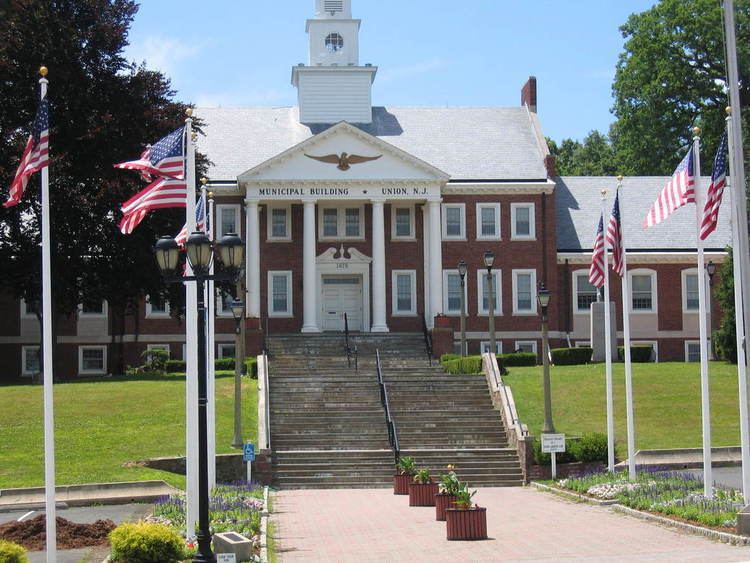
Notable buildings
Notable people
People who were born in, residents of, or otherwise closely associated with Union Township include: