
Highest elevation 600 m (2,000 ft) Elevation 600 m | Width 9 km (5.6 mi) Region MIMAROPA Max length 20.1 km | |
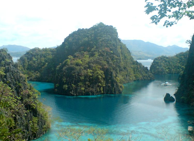 | ||
Archipelago Calamian Group of Islands Points of interest Banul Beach, Twin Lagoon Entrance, Kayangan Lake, Atwayan Beach, Calamian Islands Travel | ||
Most beautiful place on earth philippines coron island palawan
Coron is the third-largest island in the Calamian Islands in northern Palawan in the Philippines. The island is part of the larger municipality of the same name. It is about 170 nautical miles (310 km) southwest of Manila and is known for several Japanese shipwrecks of World War II vintage. Because of its unique ecological features, it is entirely protected by several legal proclamations.
Contents
- Most beautiful place on earth philippines coron island palawan
- Map of Coron Island Coron Philippines
- Geography
- Diving
- References
Map of Coron Island, Coron, Philippines
The island and surrounding fishing grounds are part of the ancestral domain of the indigenous Tagbanwa people, officially designated such on June 5, 1998. Known as Calis among the Tagbanwas and Coronians, its tribal chieftain is Rodolfo Aguilar I.
The island comprises two barangays of the municipality of Coron: Banuang Daan and Cabugao.
Geography
Partially between Busuanga and Culion islands, Coron Island faces the Sulu Sea and forms the eastern side of Coron Bay. It is about 20 kilometres (12 mi) long from north to south, and 9 kilometres (5.6 mi) at its widest point.
It is a wedge-shaped mountainous island, dominated by steep cliffs and Karst rock formations made of Permian limestone of Jurassic origin that comprises about 70% of its area. Another 25% is rolling hills, while only 5% is relatively flat. There are 11 lakes nestled in the rugged terrain, of which 3 have underground connections to the sea. There are a few mangroves in coastal areas.
Diving
The area around the wrecks has rock formations which provide for snorkeling opportunities, with underwater visibility extending up to 80 feet (24 m). The water is often calm. Coron is one of the most visited destinations for wreck diving in the Philippines. Wreck dive sites are found in depths as shallow as 10–30 feet (3.0–9.1 m) and as deep as 120–140 feet (37–43 m). Most are in the range of about 60–80 feet (18–24 m).
Dive sites around Coron include many different reef dive sites and "Günter´s Cave", also known as Cathedral Cave because during a certain time of the day, the sun throws a beam of light through a hole in the cave ceiling, illuminating the inside. It is possible to surface in the cave, as the hole in the cave-ceiling allows fresh air to enter. The cave is named after Günther Bernert, who was part of the first dive group to explore the cave, after hearing from local fishermen about its existence.
Wreck diving sites in Coron Bay include the Irako wreck, Okikawa Maru wreck, Akitsushima wreck, Kogyo Maru wreck, Olympia Maru wreck, Kyokuzan Maru wreck, East Tangat gunboat wreck (the real name of the ship, Terukaze Maru, was recently discovered by a group of Dutch divers, who spent a couple of days digging into bottom sand around the stern), Nanshin Maru wreck, Lusong Gunboat Wreck, and Skeleton Wreck.
The aquatic views from the sunken Japanese ships off Coron Island are listed in Forbes Traveler Magazine’s top-10 best scuba diving sites in the world.