
Status Retreating Area 400 km² | Length 28,000 m | |
 | ||
Thickness 400 m (1,300 ft) average | ||
The Cook Ice Cap or Cook Glacier (French: Calotte Glaciaire Cook or Glacier Cook) is a large ice cap in the Kerguelen Islands in the French Southern Territories zone of the far Southern Indian Ocean.
Contents
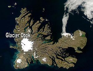
Map of Cook Glacier, French Southern and Antarctic Lands
Geography
The Cook Ice Cap reaches a maximum elevation of 1,049 metres (3,442 ft) in its central area. It had a surface of approximately 500 km2 (190 sq mi) in 1963, having shrunk to about 400 km2 (150 sq mi) in recent times.
Named after British explorer James Cook (1728–1779), on French navigational charts of the early 20th century this ice cap appears as 'Glacier Richthofen'
Glaciers
About sixty glaciers flow from the inner ice cap in a roughly radial pattern. At the feet of the snout of these outlet glaciers there are often terminal moraines with dammed lakes of varying sizes. Further down the glacial meltwaters have formed numerous outwash plains at certain, mostly inland, locations. Only one of the glaciers originating in the Cook Ice Cap has its terminus in the Indian Ocean at the Anse des Glaçons in southeastern Kerguelen's deeply indented coastline.
The following are the main glaciers listed clockwise: