
Traversed by US 395 Elevation 2,482 m | Topo map USGS Lundy | |
 | ||
Similar Sierra Nevada, Monitor Pass, June Lake Loop, Convict Lake, Deadman Summit | ||
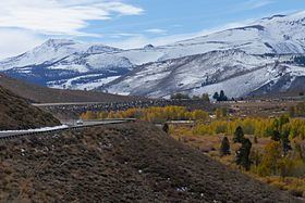
Conway summit to lee vining
Conway Summit (el. 8,143 feet (2,482 m)) is a mountain pass in Mono County, California. It is traversed by U.S. Highway 395, which connects Bridgeport and the East Walker River on the north side of the pass to Mono Lake and Lee Vining to the south. It marks the highest point on U.S. 395, which also traverses high passes at Deadman Summit and Devil's Gate Pass.
Contents
- Conway summit to lee vining
- Map of Conway Summit California USA
- Conway summit ca us 395 over mono lake geo metro 4 29 10
- References
Map of Conway Summit, California, USA
Conway Summit is named after John Andrew Conway, a settler in the area in 1880. Geographically, it was formed from an upland plateau by the sinking of the land in the Mono basin area. The Sawtooth Ridge of the eastern Sierra Nevada, topped by 12,279-foot (3,743 m) Matterhorn Peak, rise to the west of the pass; Green Creek and Virginia Lakes, in the Sierra Nevada to the west of the pass, are two local destinations for fishing, camping and aspen trees. The Bodie Hills and the infamous Bodie ghost town lie to the east.