
Country United States Time zone Eastern (EST) (UTC-5) Zip code 44030 Local time Saturday 4:05 PM | Settled 1799 Elevation 197 m Population 12,877 (2013) | |
 | ||
Incorporated 1834 (village)1902 (city) Weather -4°C, Wind N at 10 km/h, 56% Humidity Points of interest Markko Vineyard, Middle Road Covered, El Camp Lanes, Conneaut Railroad Museum | ||
316 madison street conneaut ohio 44030 life s just better here
Conneaut (/ˈkɒni.ɔːt/; KON-ee-ot) is a city in Ashtabula County, Ohio, United States, along Lake Erie at the mouth of Conneaut Creek. The population was 12,841 at the 2010 Census. Conneaut is located at the far northeastern corner of the state.
Contents
- 316 madison street conneaut ohio 44030 life s just better here
- Map of Conneaut OH 44030 USA
- History
- Geography
- 2010 census
- 2000 census
- Economy
- Government
- Transportation
- Notable people
- References
Map of Conneaut, OH 44030, USA
History
Conneaut is located on an old Native American trail, later used by early westbound pioneers. The word conneaut comes from the Seneca language, and has a disputed meaning. A Mississauga village was located at or near Conneaut, c. 1747. Conneaut was originally named Salem, and the parts surrounding it were named "Lakeville" from 1944–1964, though these were eventually combined into what is now known as "Conneaut". People still refer to parts of Conneaut as Lakeville or Amboy.
Conneaut was described in 1833 as having a printing office, one meeting house, two taverns, and several stores and shops.
On March 27, 1953 a three-train collision near Conneaut resulted in the deaths of 21 persons.
Geography
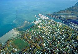
Conneaut is located at 41°57′N 80°34′W (41.9433, -80.5695). According to the United States Census Bureau, the city has a total area of 26.43 square miles (68.45 km2), of which 26.36 square miles (68.27 km2) is land and 0.07 square miles (0.18 km2) is water. Conneaut is situated along Lake Erie at the mouth of Conneaut Creek.
Conneaut is located in the northeastern-most corner of Ohio, bordering the state of Pennsylvania to the east and has 27 square miles (70 km2) within its corporate city limits.
Conneaut is a mixture of urban areas and rural farmland. The city has over seven miles (11 km) of shoreline along Lake Erie, with beaches, boating facilities and a healthy summer tourist trade.
2010 census
As of the census of 2010, there were 12,841 people, 4,740 households, and 3,034 families residing in the city. The population density was 487.1 inhabitants per square mile (188.1/km2). There were 5,702 housing units at an average density of 216.3 per square mile (83.5/km2). The racial makeup of the city was 89.8% White, 7.5% African American, 0.2% Native American, 0.4% Asian, 0.4% from other races, and 1.8% from two or more races. Hispanic or Latino of any race were 1.8% of the population.
There were 4,740 households of which 29.2% had children under the age of 18 living with them, 44.2% were married couples living together, 14.2% had a female householder with no husband present, 5.7% had a male householder with no wife present, and 36.0% were non-families. 30.3% of all households were made up of individuals and 14% had someone living alone who was 65 years of age or older. The average household size was 2.37 and the average family size was 2.90.
The median age in the city was 39.6 years. 20.2% of residents were under the age of 18; 9.2% were between the ages of 18 and 24; 28.2% were from 25 to 44; 26.5% were from 45 to 64; and 15.7% were 65 years of age or older. The gender makeup of the city was 54.4% male and 45.6% female.
2000 census
As of the census of 2000, there were 12,485 people, 5,038 households, and 3,410 families residing in the city. The population density was 473.4 people per square mile (182.8/km²). There were 5,710 housing units at an average density of 216.5 per square mile (83.6/km²). The racial makeup of the city was 96.33% White, 1.12% African American, 0.18% Native American, 0.47% Asian, 0.05% Pacific Islander, 0.23% from other races, and 1.61% from two or more races. Hispanic or Latino of any race were 1.06% of the population. 19.7% were of German, 16.0% Italian, 13.7% English, 12.0% Irish, 6.2% American and 6.2% Finnish ancestry according to Census 2000. There were 5,038 households out of which 30.4% had children under the age of 18 living with them, 52.3% were married couples living together, 11.4% had a female householder with no husband present, and 32.3% were non-families. 27.9% of all households were made up of individuals and 13.5% had someone living alone who was 65 years of age or older. The average household size was 2.45 and the average family size was 2.98.
In the city the population was spread out with 25.2% under the age of 18, 7.7% from 18 to 24, 27.5% from 25 to 44, 22.4% from 45 to 64, and 17.2% who were 65 years of age or older. The median age was 38 years. For every 100 females there were 94.2 males. For every 100 females age 18 and over, there were 89.4 males.
The median income for a household in the city was $31,717, and the median income for a family was $37,955. Males had a median income of $31,964 versus $21,198 for females. The per capita income for the city was $14,703. About 10.7% of families and 13.0% of the population were below the poverty line, including 20.3% of those under age 18 and 9.1% of those age 65 or over.
Economy
Major industries within the city include CSP of Ohio (formerly Venture Industries), General Aluminum (automotive parts), and CW Ohio (windows and pillars). The city's historic business district and its harbor business district are not as thriving as in the past. A few of the main businesses that anchor the downtown are Gerdes Pharmacy and Orlando Brothers grocery store.
Government
The city has been operated under a council-manager government since 1992.
Transportation
Transportation services Conneaut via Interstate 90, which bisects the city, along with an international shipping port and three railroads.