
OS grid reference TQ383908 Region London Sovereign state United Kingdom Dialling code 020 Post town London | Country England Postcode district E14 Ceremonial county Greater London | |
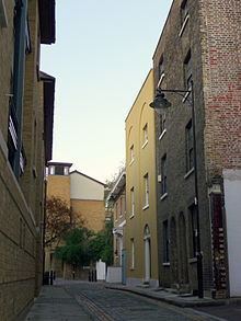 | ||
Coldharbour is an area in the Docklands of London which lies on the north bank of the River Thames, east of Canary Wharf. The area is said to be "[t]he sole remaining fragment of the old hamlet of Blackwall" and "one of the last examples of the narrow streets which once characterised the river's perimeter".
Contents
Toponymy
The placename Coldharbour came in use from the early seventeenth century and its origins have been debated since the 1850s. Conflicting etymologies are given by authorities, with Ernest Weekley contending that "[t]his name is very frequently, and very unnecessarily, discussed. Its origin is quite well known, and it means what it appears to mean."
Those accepting the plainest derivation argue that a cold harbour was a "shelter of bare walls... used by travellers who carried their own bedding and provisions", often along a well-known route and similar to a modern bothy.
In alternative, a "coldharbour" could indicate ancient boundary marks in the form of artificial mounds of earth from Roman times, often filled with crockery or charcoal. The word could be derived either from the Latin collis arborum, meaning "hill with trees", or from the Anglo-Saxon col, meaning "coal" or "charcoal", har, "hoary" or "ancient", and bearth, a mound. The link with Roman roads has been contested on the basis that the proximity of Roman roads provides a statistically weak explanation and the fact that the name is not recorded before 1590.
It has also been suggested that most Coldharbour sites could have been named in a mocking manner after a dilapidated London aristocratic house. Other interpretations include "a place where goods were once... assembled for inland water transport or for portage."
Development
Coldharbour was originally a path on the top of the late Mediaeval embankment of the Thames connecting Blackwall Stairs to "somewhere near the present entrance to the south dock of the West India Docks".
The first buildings on Coldharbour appeared by the second decade of the seventeenth century, probably as part of the activities spreading on the Thames riverfront after the opening of the East India Company's shipbuilding yard at Blackwall in 1614. A "ribbon of development" alongside the river at Coldharbour is marked on Joel Gascoyne's map of the Parish of St Dunstan's of 1703, comprising "dwelling houses, public houses, storehouses and warehouses ... interspersed with wharves, yards and even gardens."
John Betjeman describing Coldharbour as a place "where some fine Georgian merchants' houses have the water washing up to their walls". Although the oldest surviving buildings date back to the early nineteenth century, "many of the riverside sites retain an integrity which can be traced back to the seventeenth and eighteenth centuries."
The opening of the West India Docks (in 1802) and the City Canal (in 1805) cut off Coldharbour from the rest of the riverside road, with traffic being diverted to a newly built Bridge Road (later New Road, now Preston's Road) in 1817. Evidence of land reclamation, probably related to the digging of the docks and canals in the early nineteenth century, was identified by an archaeological survey. These changes gave Coldharbour its present layout as "a tiny loop road off Preston's Road," upon which architectural critic Ian Nairn remarked: "You will know a bit about East End topography by the time you find this one."
The area between Coldharbour and Preston's Road was progressively developed from the eighteenth century with dwellings around the northern end and mixed industrial premises, including shipwrights, joiners, mast- and blockmakers, ship's smiths, a rigging house, a cooperage, a boot-building yard, coppersmiths, wholesale ships' ironmongers and oil merchants.
As part of the revival of the Docklands, in 1997 the land of 17 Coldharbour was redeveloped by the Bethnal Green and Victoria Park Housing Association with a £370,000 grant from the London Docklands Development Corporation's housing programme.
Character of the area
An investigator compiling Booth's poverty maps noted the following about the Isle of Dogs and Coldharbour: "A great many more people work there than live there, though many of those who live there would like to work there. Those who live there seldom leave. From week to week and year to year the men who are islanders remain there."
Famous local individuals
Heritage
The industrial and maritime activities of Coldharbour's past are no more and today the area is largely residential. The Coldharbour conservation area, designated in 1975 and expanded in 2008, comprehends several historic buildings as well as engineering structures pertaining to the former docks.
Listed buildings
The area is said to be "[t]he sole remaining fragment of the old hamlet of Blackwall" and "one of the last examples of the narrow streets which once characterised the river's perimeter". The modern surroundings, which include Canary Wharf and The O2 Arena, contribute to "making this surviving pocket all the more valuable and remarkable."
Several buildings in the conservation area, dating mostly to the late 18th and early 19th century, have listed status:
Isle House, at no. 1, was built in 1825–6 by the West India Dock Company and used as a dock master's residence until the 1880s. Reputed to be "the finest house in Coldharbour," it was built with two storeys raised above a tall basement and full-height bow-windows on the east and north fronts to give the occupants clear views of the Thames and the Blackwall entrance to the Docks.
Notable engineering structures include the northern entrance to the West India Basin and the entrance to the former City Canal, which cut across the peninsula and gave the "Isle" of Dogs its insular title. Public access to the street, entrance locks and to the perimeter of the Blackwall Basin and Graving Dock is maintained.
The riverside
An extension of the Thames Path runs along Coldharbour, where the river view is obstructed by a series of buildings. Public access to the riverside is possible at the former entrance to Blackwall Basin, now sealed, and by Lockeryard Pier, where the path rejoins the Thames waterfront at the height of Stewart St.
The architectural critic Ian Nairn noted that this "particular bit of the riverside is the sharpest part of the curve around Blackwall Point. Nowhere is the muddy horizontal excitement of the Thames more urgent than here, [...] the curvature making sure that the maximum amount of swift-running water stays in view."
Geography
Coldharbour is situated in the London Borough of Tower Hamlets and is bounded by Landons Close to the north, by Marsh Wall to the south, by Preston Road and Wood Wharf to the west and by the river Thames to the east.
BBC World Service editor Andrew Whitehead described it as a "little enclave of riverine London ... spitting distance from Canary Wharf but sealed off from it by dock basins, new developments, and sturdy boundary walls."
Docklands Light Railway
While there are no stations in Coldharbour, the nearest station is Blackwall DLR station in neighbouring Blackwall on the Docklands Light Railway in Travelcard Zone 2 that opened on 28 March 1994.
London Buses
Roads
Coldharbour is connected to the National Road Network by the north-south Prestons Road A1206.