
Traversed by D207 Elevation 1,188 m | ||
 | ||
Similar Alps, Col de la Madeleine, Col du Glandon, Col du Mollard, Col de la Croix de Fer | ||
Col du grand cucheron 997 s 08 2012
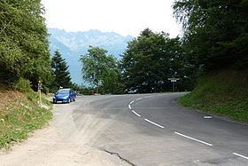
Col du Grand Cucheron, at an elevation of 1,188 metres (3,898 ft), is a mountain pass in the Alps in the department of Savoie in France. The pass crosses the northern end of the Belledonne massif, connecting the Maurienne and Isère valleys. The climb to the col was used on Stage 12 of the 2012 Tour de France.
Contents
- Col du grand cucheron 997 s 08 2012
- Map of Col du Grand Cucheron 73220 Le Pontet France
- Col du grand cucheron
- Details of the climbs
- Appearances in Tour de France
- References
Map of Col du Grand Cucheron, 73220 Le Pontet, France
Col du grand cucheron
Details of the climbs
From Les Granges (near Le Pontet) (west) the ascent is 4.01 kilometres (2.49 mi) long. Over this distance, the elevation changes by 314 metres (1,030 ft) at an average gradient of 7.8 percent.
From La Corbière (near Saint-Pierre-de-Belleville) (east), the climb is 11.61 kilometres (7.21 mi) long, gaining 805 metres (2,641 ft) at an average of 6.9 percent. This will be the direction from which the col is climbed in the 2012 Tour de France.
The climb can also be accessed from Aiguebelle (northeast) from where the route is 16.3 kilometres (10.1 mi) at an average of 5.3 percent, gaining 870 metres (2,850 ft). This route connects with that from La Corbière just after passing through Saint-Georges-des-Hurtières.
Appearances in Tour de France
The pass was first included in the Tour de France in 1972 and has since featured three times, most recently in 1998. It is generally ranked as a Category 2 climb. It was crossed on Stage 12 of the 2012 tour, between Saint-Jean-de-Maurienne and Annonay-Davézieux, approaching from the direction of Saint-Pierre-de-Belleville.