
First ascent Unknown | Mountain type Karstic Elevation 1,785 m | |
 | ||
Similar Pic de Cagire, Pic de Crabère, Pic de Sauvegarde, Mont Valier, Arbizon | ||
Pic du gar et pic saillant
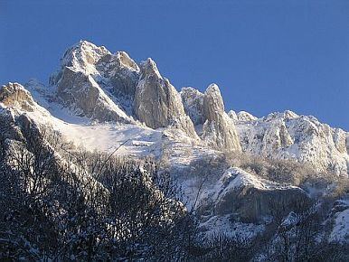
Pic du Gar is a mountain of the Pyrenees. It is located near Saint-Béat, Haute-Garonne département, in the Comminges natural region. The limestone mountain has an altitude of 1,785 metres (5,856 ft) above sea level.
Contents
- Pic du gar et pic saillant
- Map of Pic du Gar 31440 Bezins Garraux France
- Pic du gar pic du saillant parapente
- References
Map of Pic du Gar, 31440 Bezins-Garraux, France
Despite its relatively low altitude the Pic du Gar, like the Pic de Cagire, is a well-known summit of the Haute-Garonne. Its imposing silhouette dominates the high valley of the Garonne, after flowing from the Val d'Aran. Its secondary summit, the Pic Saillant (1756 m), has a summit cross.
Pic du gar pic du saillant parapente
References
Pic du Gar Wikipedia(Text) CC BY-SA