
Spans: 3 Opened 1970 | Constructed 1969 | |
 | ||
Roads atjunction: Barrington Street, Cogswell Street, Upper Water Street, Hollis Street Type: Multi-level interchange Maintained by: Halifax Regional Municipality and Province of Nova Scotia | ||
Down with the cogswell interchange
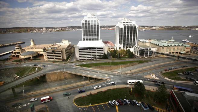
The Cogswell Interchange is a multi-level highway interchange in downtown Halifax, Nova Scotia, Canada. It was built as the first stage of a greater scheme for an elevated freeway, called Harbour Drive, which would have run south through downtown and necessitated demolition of much of the downtown building stock. The plan was halted in the face of significant public opposition, but the Cogswell Interchange remains a visible reminder, occupying a large amount of prime land and posing a barrier to pedestrian movement. As the interchange is functionally obsolete and increasingly expensive to maintain, the municipal government has commissioned several studies proposing its demolition and replacement with a more conventional street grid.
Contents
The cogswell interchange a promo of sorts
Origins
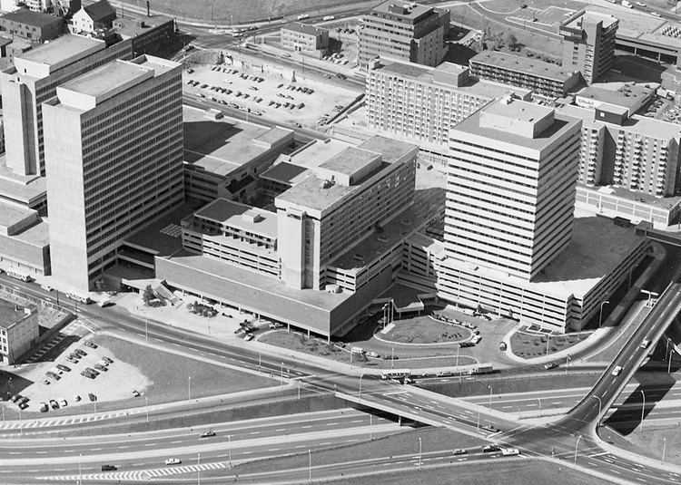
The city began purchasing land and demolishing buildings in the 1950s in anticipation of the highway construction. In the 1960s, urban renewal planning was underway all over North America and Europe, and Halifax was no exception. In 1962, the city placed advertisements in newspapers seeking development proposals for the Central Redevelopment Area, an area of several city blocks worth of older wood-framed buildings. This eventually became Scotia Square, a complex of office, residential and hotel towers atop parking garages and a shopping mall.
The developers of Scotia Square, a project of a scale hitherto unattempted in the Maritimes, stressed the importance of improved transport infrastructure to the complex and commissioned a study recommending a conceptual precursor to "Harbour Drive", a proposed elevated freeway running parallel to the water, similar to the Gardiner Expressway in downtown Toronto.
A.D. Margison & Associates, successor to the firm which designed the Gardiner Expressway decades earlier, was hired by the city in 1967 to formally design the new highway and interchange. Opposition to the plan began to mount, led by the Nova Scotia Association of Architects with Allan F. Duffus at the helm. Many architects, engineers and planners spoke out against the destruction of the historic urban core and stated that it was not too late to build "simpler roads," which would require less demolition. Duffus produced an alternate plan, which A.D. Margison & Associates said would "overload the streets with traffic by 1970" and was rejected by city council, which feared that any changes to the interchange plan would jeopardise tenancy agreements made with respect to Scotia Square.
After demolition of the remaining buildings on the site, construction of the interchange began in 1969. It opened in 1970, the same year the municipal government recanted and cancelled construction of the remainder of Harbour Drive. It then cost $5.8 million.
Future
In the decades since construction, the interchange has become a much-maligned feature of downtown Halifax. It is widely considered excessively large and pedestrian unfriendly. It separates downtown from the North End and the waterfront from the uphill areas.
Numerous plans have been put forth for its demolition. The most current, the Cogswell Interchange Lands Plan, is currently in the detailed design stage.
The plan aims to offer quality urban design and promote economic development through a number of goals:
On September 20, 2016, the municipal government voted to hire a company to develop a plan for its removal and replacement by a more appropriate road network.
Responsibility
The municipality and the province share responsibility for maintenance of the bridge spans. The municipality is responsible for the road surfaces and the retaining walls.