
Length 44 km | Source elevation 85 m | |
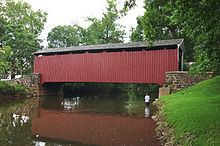 | ||
Main source Stricklerstown, Pennsylvania1,320 feet (400 m) Basin size 140 square miles (360 km) Bridges Zook's Mill Covered Bridge, Keller's Covered Bridge, Butcher's Mill Covered Bridge | ||
Cocalico Creek is a 27.2-mile-long (43.8 km) tributary of the Conestoga River in Lebanon and Lancaster counties in Pennsylvania in the United States. The source is at an elevation of 1,320 feet (400 m) near Stricklerstown in Millcreek Township, Lebanon County. The mouth is the confluence with the Conestoga River at an elevation of 278 feet (85 m) at Talmage in West Earl Township, Lancaster County.
Contents
Map of Cocalico Creek, Pennsylvania, USA
The name of the creek comes from the Lenape, meaning "snake dens". It comes from the Lenape word Gookcalicunk (pronounced "Gook Cal-eek Unk) which means “Snake Sleep Place” in English. The Lenape considered modern East Cocalico, West Cocalico, Clay, Warwick, Elizabeth, and Penn townships, Lancaster County, Mill Creek Township, Lebanon County, and the Middle Creek Wildlife Management Area as part of Gookcalicunk.
Cocalico Creek flows south for 10 miles (16 km), then southwest 16 miles (26 km). The Cocalico Creek watershed has a total area of 140 square miles (360 km2) and is part of the larger Chesapeake Bay drainage basin via the Susquehanna River.