
OS grid reference TL086380 Sovereign state United Kingdom Dialling code 01525 | Unitary authority Local time Tuesday 12:48 PM | |
 | ||
Population 1,750 1,738 (2011 Census) Weather 9°C, Wind W at 11 km/h, 65% Humidity | ||
Clophill is a small village and civil parish located in the Flit river valley, Bedfordshire, England. It is recorded in the Domesday Book of 1086 as Clopelle; meaning tree-stump Hill in old English.
Contents
- Map of Clophill UK
- St Marys old church
- New churches
- Public houses
- Notable residents
- Sports and Leisure Facilities
- References
Map of Clophill, UK
The Domesday Book entry reads: Clopelle: Nigel d'Aubigny.
In the 1851 census, out of a total male population in Clophill of 560, there were some 238 agricultural labourers; some years later in 1871 census, out of a total female population in Clophill of 655.
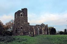
St Mary's old church
The old St Marys Church was built around 1350, and replaced by a new church in the 1840s. The old church gradually fell into ruin, and has recently had restoration work carried out on it.
New churches
The new St Mary's church is located in the High Street in the village. It was built 1848-1849. The current rector is the Rev Dean Henley. In addition to St Mary's, which is Church of England, there is also the Clophill Methodist Church.
Public houses
Notable residents
Sports and Leisure Facilities
Both the Greensand Ridge Walk and the Greensand Cycle Way pass through Clophill.