
NRHP Reference # 72000638 Year built 1838 | Area 21 ha Added to NRHP 24 March 1972 | |
 | ||
Location Clinton Township to Rochester | ||
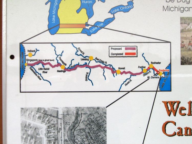
The Clinton–Kalamazoo Canal is a canal in Michigan that was abandoned after being only partially completed. The canal was to connect Lake St. Clair with Lake Michigan. Project backers were inspired by the success of the Erie Canal in New York, which was completed in 1825. After gaining statehood in 1837, Michigan elected its first governor, Stevens Thomson Mason, who initiated an ambitious program of internal improvements, including three railroads and two canals.
Contents
History
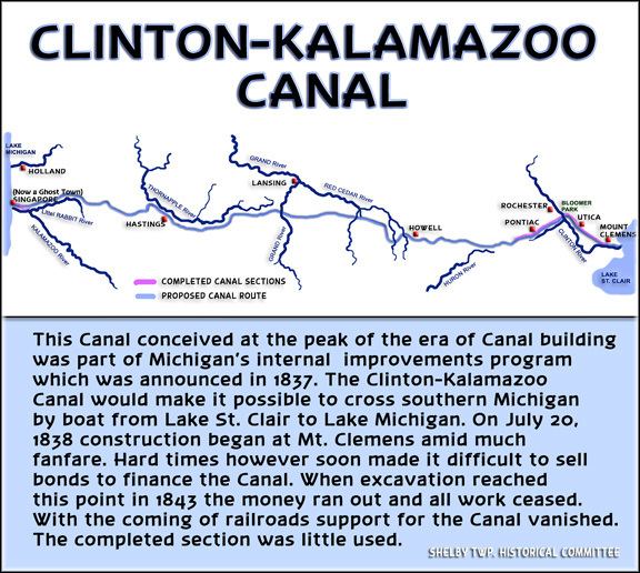
The Clinton–Kalamazoo Canal was to begin in Mount Clemens on the banks of the Clinton River and continue through Utica, Rochester, Pontiac, Howell, Hastings, and finally to the mouth of the Kalamazoo River. In all, the canal was to span 216 miles. From Pontiac westward, the canal would carry new settlers and supplies to the interior of the state and eventually connect with the "thriving" Lake Michigan port of Singapore (now a ghost town). Singapore was to ship passengers and freight to Chicago across Lake Michigan.
The valley of the Clinton river was thought to present a feasible water-route to Lake St. Clair, and the matter of improving the navigation of the river was pushed so persistently that the legislative council of the Territory passed an act (approved by the governor April 12, 1827) incorporating the 'Clinton River Navigation Company" for the purpose of removing obstructions from the Clinton river, and making such river navigable for boats from the village of Mount Clemens to Mack's lower mills (so called), in the county of Oakland."
The length of this proposed improvement was about thirty miles, and it was calculated that it would afford invaluable shipping facilities to a large extent of rich agricultural country. It was the first incorporated company for similar purpose in the Territory and likely would have succeeded except that it was surpassed by railway construction. The incorporators of this company were Nathaniel Millard, Jonathan Kearsley, Levi Cook, Charles Larned, Ellis Doty, John R. Sheldon, Christian Clemens, Alfred Ashley, Jacob Tucker, Ignace Morass, and Joseph Hayes. The company were required, under the act of incorporation, to clear out the river to the east line of Oakland County, commencing on or before the first day of July, 1827, and when they had made it navigable for flat-bottomed boats or bateaux to the line of the county, they were to be entitled to collect toll, not exceeding fifty cents per ton for the whole distance, and proportionally for less distances. When the river was made navigable as far as Mack's mill, and a good tow-path constructed on one bank, the company were entitled to demand toll not exceeding seventy-five cents per ton for the whole distance, and in proportion for a less distance.
Parties owning water-power on the river below the east line of Oakland County were required to construct locks at every dam sufficient for the passage of the company's boats. The river above the said line was declared by the act of incorporation a public highway, but persons owning land extending across the river had the right to construct dams for water-power purposes by putting in the necessary locks, or the company could construct them at the expense of the parties owning the lands. The improvements were finally completed as far as Rochester, a portion of the State loan of five millions being appropriated to the work. Business was carried on to a small extent for a number of years, but the enterprise was never a prosperous one.
Construction began in 1838 with much fanfare. Financial troubles related to the Panic of 1837 caused funding for the canal to disappear. All construction stopped in 1843 after only 13 miles had been completed. Many workers who were unpaid destroyed parts of the canal and stole supplies. Engineering miscalculations also contributed to the canal's failure, as the canal was dug too shallow and too narrow for heavy freight barges.
About 1844, Amos Brown, of Rochester, constructed and launched a log flatboat, and, collecting a party of his friends, they proceeded to celebrate the occasion by a grand ride on the canal ; but when they came- to the first lock they found their craft too wide to admit of a passage. The locks were constructed of logs, and the pressure of the superincumbent earth against their sides had sprung them in, narrowing the space considerably. A fellow who had served a term in the State prison made quite a speculation by burning some of the locks and selling the old iron.
After construction ended, the canal quickly fell into disrepair. Portions were used as a millrace to power watermills that operated until the 1940s. The canal was added to the National Register of Historic Places in 1972. The route of the canal has been marked by signs and historic markers.
Today
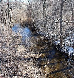
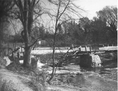
Remnants of the canal are still visible in Rochester Hills in Oakland County and in Shelby Township, Utica and Clinton Township in Macomb County. Much of the canal is clearly visible in parks and along Canal Road in Clinton Township. The remains of the aqueduct built over the Clinton River can be seen in Yates Park, and two wood dams can be seen in the river in Canal Park and Bloomer Park. No locks are visible along the canal but the locations of a few are known.