
Community Scarborough | ||
 | ||
Restaurants Dolphin Gaming, Tatami Sushi, Ital Vital Restaurant, Watts Restaurant, Shawarma Boss | ||
Clairlea is a neighbourhood of Scarborough, in the city of Toronto, Ontario, Canada. The neighbourhood is located in the western part of Scarborough just east of Victoria Park Avenue. To the north it is bounded by Eglinton Avenue and to the south by Taylor-Massey Creek and the railway tracks.
Contents
Map of Clairlea, Toronto, ON, Canada
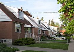
In the 19th century the intersection of St. Clair and Victoria Park was home to a small village named Moffat's Corners, and the rest of the region was rural. Clairlea was one of the first parts of Scarborough to be developed as a Toronto suburb, being transformed in the early 1950s. Today it is a middle income neighbourhood that features many affordable homes and mature streets. The Warden Woods ravine is the landmark of the neighbourhood, offering some downtown nature.
People
There is a large Filipino contingency in this neighbourhood, at least compared to the rest of the city (8%) and a correspondingly large number of residents who speak Tagalog. Filipino born individuals accounted for 2% of this census tract population in 2006, in 2011 Filipino born dwellers made up 9.9 % of the total CT population. This is not surprising as in 2011, Philippines went from third most common Place of Birth in Canada to first most common (Census Canada, 2006, NHS, 2011). The neighbourhood is quite diverse from languages spoken to religions practiced which is typical in the city of Toronto.