
Time zone CET (UTC+1) Local time Monday 10:15 AM Postal code 64010 | Demonym(s) Civitellesi Elevation 589 m | |
 | ||
Frazioni Borrano, Carosi, Cerqueto del Tronto, Collebigliano, Collevirtù, Cornacchiano, Favale, Fucignano, Gabbiano, Le Casette, Lucignano, Mucciano, Pagliericcio, Palazzese, Piano Risteccio, Piano San Pietro, Ponzano, Ripe, Rocche, Santa Croce, Sant'Andrea, Santa Maria, Santa Reparata, Sant'Eurosia, Tavolaccio, Valle Sant'Angelo, Villa Chierico, Villa Lempa, Villa Notari, Villa Passo, Villa Selva Weather 14°C, Wind SW at 18 km/h, 47% Humidity | ||
Frana civitella del tronto immagini
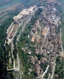
Civitella del Tronto is a town and comune in the province of Teramo, within the Abruzzo region of central Italy. It is located in the Gran Sasso e Monti della Laga National Park.
Contents
- Frana civitella del tronto immagini
- Map of 64010 Civitella del Tronto Province of Teramo Italy
- History
- Main sights
- Twin towns
- References
Map of 64010 Civitella del Tronto Province of Teramo, Italy
History
The origins of Civitella are unknown, though in the area have been found traces of human presence as early as the Neolithic and Upper Palaeolithic ages. The current town is believed to lie on the former Beregra, a town of the Piceni Italic tribe. It is first mentioned in the 10th-11th centuries, as a walled town; in the 13th century it was part of the Kingdom of Naples, having a special importance as it was located on the boundaries with the Papal States.
In 1557 it was besieged by French troops, but in vain. Thanks to its fierce resistance, it was given the title of Fidelissima ("Very Faithful") by King Philip II of Spain (at the time southern Italy was under Spanish control). Civitella was besieged again by the French during the Napoleonic Wars, in 1798 and 1806, this time being captured after four months of defence. In 1816, after the Congress of Vienna, it was annexed to the Kingdom of the Two Sicilies.
The fortress of Civitella was the location of the last stand of that Kingdom after the Garibaldine and Piedmontese invasion of 1860, after the King Francis II had already surrendered in Gaeta, Naples and Sicily being annexed to the newly formed Kingdom of Italy. Civitella surrendered on 20 March 1861.
Main sights
The Fortress of Civitella is the largest in Italy, the second in Europe after the Hohensalzburg in Salzburg, Austria. It is located on the top of a rocky cliff, being about 500 metres (1,600 ft) long and 45 metres (148 ft) wide, for a total surface of 25,000 square metres (270,000 sq ft).
The town has the following churches:
The surrounding mountains have karst topography in the landscapes of the Montagna dei Fiori.