
Status Open all year | Phone +593 2-239-4803 | |
 | ||
Type Museum park and monument Similar Intiñan Solar Museum, Compañía de Jesús - Quito, La Capilla del Hombre, Church and Convent, El Panecillo | ||
Video institucional empresa p blica de turismo ciudad mitad del mundo ecuador
The Ciudad Mitad del Mundo ([sjuˈðað miˈtað ðel ˈmundo], Middle of the World City) is a tract of land owned by the prefecture of the province of Pichincha, Ecuador. It is located at San Antoñio parish of the canton of Quito, 26 km north of the center of Quito. The grounds contain the Monument to the Equator, which highlights the exact location of the Equator (from which the country takes its name) and commemorates the eighteenth century Franco-Spanish Geodesic Mission which fixed its approximate location; they also contain the Museo Etnográfico Mitad del Mundo, a museum about the indigenous ethnography of Ecuador.
Contents
- Video institucional empresa p blica de turismo ciudad mitad del mundo ecuador
- Ciudad mitad del mundo
- Monuments geographical imprecision
- Latitude discrepancy
- Intian Solar Museum
- References
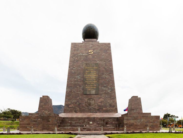
The 30-meter-tall monument was constructed between 1979 and 1982 by Pichincha's Province Council to replace an older, smaller monument built by Government of Ecuador under the direction of the geographer Luis Tufiño in 1936. It is made of iron and concrete and covered with cut and polished andesite stone. The monument was built to commemorate the first Geodesic Mission of the French Academy of Sciences, led by Louis Godin, Pierre Bouguer and Charles Marie de La Condamine, who, in the year 1736, conducted experiments to test the flattening at the poles of the characteristic shape of the Earth, by comparing the distance between a degree meridian in the equatorial zone to another level measured in Sweden. The older monument was moved 7 km to a small town near there called Calacalí.
The UNASUR headquarters is currently under construction. Contrary to popular belief, there are only two points of interest positioned exactly on the equator: the Catequilla archaeological site, and the Quitsato Sundial.
Ciudad mitad del mundo
Monument's geographical imprecision
The placement of the equatorial line was defined throughout a 1736 expedition called the French Geodesic Mission . While such studies would later determine the exact measure and shape of the world, astronomers involved missed the possibility of encountering the remnants of highly sophisticated geographical achievements made on “Equatorial” territory for hundreds of years before their arrival. Throughout the time the astronomers attempted to measure a length of a degree of latitude on that part of the planet, a group of different sorts of ruins (built by the Quitu-Cara culture) were found nearby the territory where they thought the Equatorial line passed through. Years after that, it was brought to light that the "Geodesic Mission" had been wrong about the exact coordinates where the line passed through—the measurements had indeed proved the world was oblate and not elongated (egg-shaped) at the poles, but their studies to define the placement of the equator were incorrect by 240 meters. The ruins found throughout the expedition between 1735-1745 where actually situated at latitude 0, or the exact position where the Equatorial line crosses.
In 1935, the Ecuadorean Government built a ten-meter high monument to honor the French expedition under the guidance of local geographer Luis Gudiño. In 1972, such monument was replaced by a thirty-meter high monument titled “Ciudad Mitad del Mundo” (Middle of the World City), regardless of the inexact coordinates (which by then could be measured through GPS.)
Latitude discrepancy
Based on data obtained by Tufiño, it was believed that the equator passed through those two sites. However, according to readings based on the World Geodetic System WGS84, used in modern GPS systems and GIS products, the equator actually lies about 240 meters north of the marked line.
Over the years, countless tourists have had their pictures taken straddling the line drawn down the center of the east-facing staircase and across the plaza.
The pyramidal monument, with each side facing a cardinal direction is topped by a globe which is 4.5 meters in diameter and weighs 5 tons. Inside the monument is a small museum that displays a variety of indigenous items pertaining to Ecuadorian culture: clothing, descriptions of the various ethnic groups, and examples of their activities.
Ciudad Mitad del Mundo contains other attractions such as a planetarium, a miniature model of Quito, and restaurants. On weekends, Ciudad Mitad del Mundo's Central Plaza hosts varied musical and cultural events for tourists. Also, there are diverse local handcraft stores and local food served at several cafés along a colonial small town.
Intiñan Solar Museum
200m northeast of the Ethnographic Museum Monument is a local private attraction, known as the Intiñan Solar Museum, reportedly built to mark the Equator, although modern measurements suggest that it no longer does.
Except for the exhibitions of Ecuadoran culture, the museum is an amusement for credulous tourists. Tour guides and visitors demonstrate tricks which are supposedly possible only on the Equator, such as water flowing both counter-clockwise and clockwise down a drain due to Coriolis effect, balancing eggs on end, or weakening of muscles due to latitude.
They even ask tourists for using the SAD69 Datum. This datum was imprecise and should be considered outdated. Some inaccurate GPS readings are due to using civilian GPS instead of military GPS. The truth, which some tour guides will admit, is that latitude has no measurable influence on these tricks; they are unrelated to the proximity of the equator.