
Headquarters Churu Average annual precipitation 43cm mm Literacy 67.5% | Major highways NH-52 Area 13,858 km² | |
 | ||
Colleges and Universities Gandhi Vidya Mandir, Institute of Advanced Studies in Education Destinations Churu, Sujangarh, Chhapar, Salasar, Sardarshahar Points of interest Salasar Balaji, Churu Fort, Tal Chhapar, Ghantaghar, Dharm stup | ||
Churu district (Hindi: चुरू जिला) is a district of the Indian state of Rajasthan in western India. The town of Churu is the administrative headquarters of the district.
Contents
- Map of Churu Rajasthan
- Attractions
- Demographics
- Percentage distribution of local work force
- Local industries
- Major crop production
- Communication facilities
- Educational facilities and institutions
- Industrial scenario
- Infrastructure
- Primary industries
- Notable people
- References
Map of Churu, Rajasthan
Churu lies in the Jangladesh region of northern Rajasthan and shares boundaries with the Hanumangarh District to the north, the Haryana state to the east, the Jhunjhunun and Sikar districts to the southeast, the Nagaur District to the south, and the Bikaner District to the west.
The district has an area of approximately 16,830 km², with a road length of 1901 km. The 2011 population was approximately 2,041,171. The gender ratio is 938 females per 1,000 males; literacy among residents is 67.46%. There are 6 tehsils in the district: Churu, Ratangarh, Taranagar, Rajgarh, Sardarshahar, and Sujangarh.
The major crops include bajra and gram. The major minerals found in the district are copper and gypsum.
Attractions
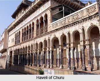
Sujangarh, Ratangarh, Sardarshahar, Tarangar, Rajgarh, Ratannagar, Chapper, Bidasar and Rajaldesar are the other major towns in the district. The Tal Chhapar Sanctuary, a blackbuck sanctuary, has more than 1,680 black bucks and migratory birds. It is a major attraction for wildlife enthusiasts. Other attractions include the grand palatial Havelies in the towns of Ratannagar, Ratangarh and Sardarshahar, the Hanuman temple at Salasar and the Venkateshwar temple at Sujangarh, the birthplace of local deity, Goga Pir, in Dadrewa. The Bhadrakali Temple at Rajaldesar is popular among Shakta Tantra followers from all over India, which was established by Anant Shri Vibhushit Dandi Swami Jogendrashram ji Maharaj. Baba Phool Nath Temple at Nawa, Rajgarh is popular and related to NATH Community.
Demographics
According to the 2011 census, Churu district has a population of approximately 2,041,172, roughly equal to the nation of Botswana or the US state of New Mexico. This gives it a ranking of 224th in India (out of a total of 640 districts). The district has a population density of 148 inhabitants per square kilometre (380/sq mi). Its population growth rate over the decade 2001-11 was approximately 6.1%. Churu has a sex ratio of 938 females for every 1000 males, and a literacy rate of about 67.46%.
Percentage distribution of local work force
Local industries
Major crop production
Communication facilities
Educational facilities and institutions
Industrial scenario
Infrastructure
A majority of the district's power supply is provided by the Bhakra Hydel Complex through 132 kV lines coming via Hissar in Haryana. 902 of the district's 926 villages have access to electricity. Water is available at the depth of 30 to 48 metres, with the exception of places such as Sujangarh and Taranagar Tehsils.
The district has good connections within and outside the state. National Highway Nos. 11 (Agra-Bikaner), 65 (Ambala-Pali), and 709 Ext. (Rohtak-Rajgarh) pass through the district. The total length of roads in the district is 3,010 km and is 240 km from Delhi via Hisar and 210 km. via Behal. The Churu district is served by broad gauge lines of the Northern-Western Railway. The total length of rail line is 363 km. The broad gauge is developing in some areas of the district. The nearest airport is at Jaipur (approximately 245 km outside the district).
Churu was ranked as 423rd in a ranking of 423 districts for the National Urban Sanitation Policy in 2009-2010. In the absence of citizen awareness, it continues to hold that rank, making it officially India's dirtiest district.(Report)