
Population 1,017 (2011) Civil parish Chulmleigh Dialling code 01769 | OS grid reference SS6814 Sovereign state United Kingdom | |
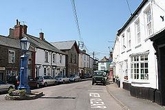 | ||
Chulmleigh (/ˈtʃʌmli/ CHUM-lee) is a small Saxon hilltop market town and civil parish located in North Devon in the heart of the English county of Devon. It is located 20 miles (32 km) north west of Exeter, just north of the Mid Devon boundary, linked by the A377 and B3096 roads. The parish is surrounded, clockwise from the north by the parishes of King's Nympton, Romansleigh, Meshaw, East Worlington, Chawleigh, Wembworthy (a short border only), Ashreigney, Burrington, and Chittlehamholt. In 2001 the population of the parish was 1,308, decreasing to 1,017 at the 2011 census. An electoral ward with the same name also exists whose total population at the same census was 2,081.
Contents
Map of Chulmleigh, UK
Chulmleigh has some very old architecture with many cob and thatched buildings. It is located close to the Tarka Railway Line. King's Nympton Railway Station is within the parish, although it is around 2 miles (3.2 km) from the town, and Eggesford station is closer to the town.
Chulmleigh has a retained fire station which is part of Devon and Somerset Fire and Rescue Service. The secondary school is the Chulmleigh Community College has been amongst Devon's highest GCSE league tables. The town's pub is the Old Court House. on South Molton Street. The parish church is St Mary Magdalene.
Local businesses and organisations include Chulmleigh Cricket Club, Chulmleigh Hardware, Winston Pincombe and Chulmleigh Golf Course.