
Founded 29 September 1560 Elevation 1,923 m (6,309 ft) Population 10,729 (2015) | Founded by Antonio Bermúdez Area 223 km² Local time Sunday 4:15 PM | |
 | ||
Weather 17°C, Wind S at 14 km/h, 64% Humidity Province | ||
Choachí is a municipality and town of Colombia in the Eastern Province of the department of Cundinamarca. The municipality borders La Calera in the north, Ubaque in the south, in the east Fómeque and westward of Choachí is the Colombian capital Bogotá. The town centre is located at 38 kilometres (24 mi) from the centre of the capital. Within the boundaries of Choachí the Páramo de Cruz Verde is situated.
Contents
Map of Choach%C3%AD, Cundinamarca, Colombia
Etymology
The name Choachí is derived from the original name in Chibcha: Chi-gua-chí, which means "Our Mountain of the Moon". The Muisca had a strong lunar cult and worshipped the goddess of the Moon, Chía in various places across their territories. It is believed that in Choachí a place of worship to the Moon was located.
History
The area of Choachí was inhabited by the southern Muisca, part of the Muisca Confederation ruled by the zipa of Bacatá. The modern foundation of the town was early in the Spanish conquest of the Muisca, in 1560, by soldiers of conquistador Gonzalo Jiménez de Quesada. In 1601 a parish was constructed in Choachí.
Between the 17th and 19th century the original indigenous population almost completely perished.
Economy
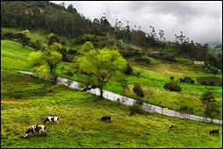
Main economical activities in Choachí are agriculture, livestock farming and mining. Also tourism, mainly from the capital, is a source of income for the local people.
Geology
In the area of Choachí Cretaceous sandstones and the organic-rich shales of the Fómeque Formation are outcropping.
Archeology
In the first half of the 20th century within Choachí the Choachí Stone has been found, possibly in a grave. The stone, carved in lydite may represent the Muisca calendar, a complex lunisolar calendar used by the Muisca. Also petroglyphs have been discovered in Choachí.