
Basin size 212.9 km (82.2 sq mi) Basin area 551.4 km² | Length 41 km | |
 | ||
Main source Monte Marzoaround 2,300 m (7,500 ft) River mouth Dora Baltea223 m (732 ft) Tributaries Left:rio Dondogna, torrente Tarva, torrente Bersella, rio Quaglia, rio RibesRight:rio Sportore, rio Ricordone, rio Trueisa, torrente Savenca Discharge Average rate:(mouth) 6.1 m/s (220 cu ft/s) | ||
World kayak river guide chiusella middle
The Chiusella (Piedmontese: Ciusèila) is a 41-kilometre (25 mi) long creek in the Piedmont region of Italy.
Contents
- World kayak river guide chiusella middle
- A wet state 90 piemonte and ticino 2014 part 2 chiusella and egua
- GeographyEdit
- TributariesEdit
- Other projectsEdit
- References
A wet state 90 piemonte and ticino 2014 part 2 chiusella and egua
GeographyEdit
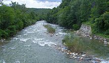
The Chiusella starts in the Graian Alps near Mount Marzo and Bocchetta delle Oche, a mountain pass connecting its valley with Val Soana. Flowing initially from NW to SE it reaches Traversella and the permanently inhabited part of the valley. In the territory of Issiglio it receives from the right side the waters of Torrente Savenca, its main tributary. The Chiusella is then blocked by a dam forming the Lake Gurzia. Flowing eastwards it forms a canyon and leaves the mountains entering the plain; near Strambino it finally flows into the Dora Baltea.
TributariesEdit
Other projectsEdit
Media related to Chiusella at Wikimedia Commons
References
Chiusella Wikipedia(Text) CC BY-SA