
Elevation 218 m (715 ft) Time zone CET (UTC+1) Area 6.6 km² Postal code 24060 | Province / Metropolitan city Bregamo (BG) Demonym(s) Chiudunesi Dialing code 035 Local time Sunday 7:00 PM Dialling code 035 | |
 | ||
Weather 10°C, Wind N at 11 km/h, 59% Humidity | ||
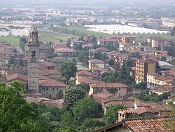
Chiuduno is a comune (municipality) in the Province of Bergamo, in Italian region of Lombardy; Chiuduno is located about 60 kilometres (37 mi) northeast of Milan and about 15 kilometres (9 mi) southeast of Bergamo, midway between the Bergamo plain and the Valcalepio.
Contents
Map of 24060 Chiuduno Province of Bergamo, Italy
Chiuduno borders the following municipalities: Bolgare, Carobbio degli Angeli, Grumello del Monte, Telgate.
History
The settlement has Gaulish origins, and was later a Roman centre as Claudunum on the road between Bergamo and Brescia. It is however mentioned for the first time in a document from 795, and in the Middle Ages it developed and received a fortress.
Main sights
References
Chiuduno Wikipedia(Text) CC BY-SA