
Area 34 ha Established August 9, 1956 | Designated August 9, 1956 Phone +1 308-586-2581 | |
 | ||
Operator Nebraska State Historical Society Address 9822 County Road 75, Bayard, NE 69334, USA Hours Closed now Saturday9AM–5PMSunday9AM–5PMMonday9AM–5PMTuesday9AM–5PMWednesday9AM–5PMThursday9AM–5PMFriday9AM–5PM Similar Courthouse and Jail House R, Independence Rock, Oregon Trail, Wildcat Hills, Carhenge | ||
Chimney rock national historic site
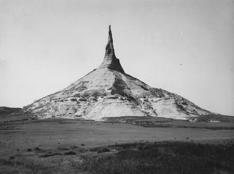
Chimney Rock is a prominent geological rock formation in Morrill County in western Nebraska. Rising nearly 300 feet (91 m) above the surrounding North Platte River valley, the peak of Chimney Rock is 4,228 feet (1,289 m) above sea level. The formation served as a landmark along the Oregon Trail, the California Trail, and the Mormon Trail during the mid-19th century. The trails ran along the north side of the rock, which remains a visible landmark for modern travelers along U.S. Route 26 and Nebraska Highway 92.
Contents
Chimney rock national historic site
History
Prior to exploration and settlement by European immigrants, the Native Americans of the area—mainly the Lakota Sioux—would refer to this formation by a term which meant elk penis. The first non-natives to see the pillar were probably the Astorians of Robert Stuart in their eastward journey from the Pacific Ocean in 1813. Chimney Rock was recorded in many journals after the Stuart expedition.
The name "Chimney Rock" probably originated from early fur traders. The first recorded mention of "Chimney Rock" was in 1827 by Joshua Pilcher. Pilcher had journeyed up the Platte River valley to the Salt Lake rendezvous of the Rocky Mountain fur trappers. The formation went through a variety of names before becoming Chimney Rock such as Chimley Rock and Chimney Tower, as well as euphemisms based on the original Native American name, such as Elk's Peak and Elk Brick.
A small town named Chimney Rock once stood near the base of the formation. A post office was established at the town of Chimney Rock in 1913, and remained in operation until 1922.
Based on sketches, paintings, written accounts, and the 1897 photograph by Darton, Chimney Rock was taller when it was first seen by settlers, but has since been reduced in height by erosion and lightning.
Geology
The pillar consists primarily of Brule clay interlayered with volcanic ash and Arikaree sandstone. The harder sandstone layers near the top have protected the pillar since it broke away from the retreating cliff line to the south. Chimney Rock rises approximately 286 feet (87 m) above its surroundings.
Today
Chimney Rock was designated a National Historic Site on August 9, 1956 and is a National Park Service designated area, though it is maintained and administered by the Nebraska State Historical Society. Chimney Rock and Independence Rock further west in Wyoming are two of the prominent features along the Oregon Trail. Chimney Rock is located 20 miles southeast of Scotts Bluff National Monument, on Nebraska Highway 92.
The Ethel and Christopher J. Abbot Visitor Center features museum exhibits and a video about pioneers and the migrations in the West, as well as a gift shop.
On March 1, 2006, the Nebraska State Quarter was released. The quarter features a covered wagon headed west past Chimney Rock, commemorating Nebraska's role in westward migration.