
Length 33 mi (53 km) | Use Hiking, Biking | |
 | ||
Lowest point about 650 ft (198 m) in Jacksonville | ||
The Chief Ladiga Trail /ləˈdaɪɡə/ is a rail trail in Alabama. It is the state's first rail trail project.
Contents
Map of Chief Ladiga Trail, Alabama, USA
Trail background
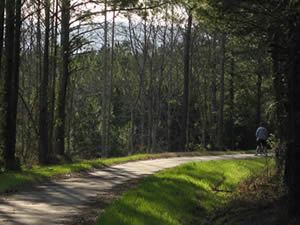
The 33-mile (53 km) trail stretches from the Alabama-Georgia state line to Weaver. The Chief Ladiga is on the same rail corridor as the Silver Comet Trail in Georgia as far as Piedmont, Alabama. From there it parallels an abandoned Southern Railway line for a few miles west of town until it leaves the old Seaboard rail line, heading south on the Southern Railway route until the trail ends just north of Anniston. As of August, 2007, pavement is continuous between the Ladiga and Comet trails. A new gateway marks the connecting point at the state line. Now that the Chief Ladiga and the Silver Comet trails are connected, there is a 90-mile (145 km) paved corridor for non-motorized travel from just west of Atlanta, Georgia to Anniston, making it the 2nd longest paved trail in the U.S. (the longest being the Paul Bunyan in Minnesota.)
Chief Ladiga
Chief Ladiga was a Muscogee chief who relinquished his tribe's lands when he signed the Treaty of Cusseta in 1832. The Treaty was part of a broader policy of indian removal perpetrated by the Jackson Administration. Ladiga sold half his land (which would later become Jacksonville) to speculators for $2000.
Route
The Chief Ladiga Trail starts at the Alabama-Georgia state line. At about mile marker 7.0, the trail crosses the Pinhoti National Recreation Trail. It travels west to Piedmont then on to Jacksonville and Weaver and finally ending at Mike Tucker Park in north Anniston. It travels through wetlands, across streams, through forests and farmlands, and includes a horizon view of the Talladega Mountains. There are several bridges and both new and restored railroad trestles.