
County Plumas FIPS code 06-12930 Elevation 1,382 m Zip code 96020 Area code Area code 530 | Time zone Pacific (PST) (UTC-8) GNIS feature IDs 277487; 2408021 Area 19.08 km² Population 2,144 (2010) | |
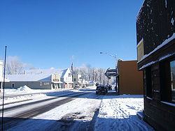 | ||
Chester (formerly Big Meadows) is a census-designated place (CDP) in Plumas County, California, United States. Chester is located on Lake Almanor, 30 miles (48.3 km) north-northwest of Quincy. The town is located along State Route 36. The US Postal Service ZIP code for the community is 96020. The population was 2,144 at the 2010 census, down from 2,316 at the 2000 census.
Contents
Map of Chester, CA 96020, USA
The primary industries in Chester are lumber production and tourism. Chester serves as the retail center for the Lake Almanor region of California, and derives a significant portion of its economy from the tourist trade, and to a lesser degree from construction to new residents and businesses.
History
The town was founded and named by two settlers, one from Chester, Vermont, and another from Chester, Missouri. The Chester post office opened in 1894 and moved in 1908.
Geography
Chester is located at 40°18′10″N 121°14′5″W (40.302395, -121.234672).
According to the United States Census Bureau, the CDP has a total area of 10.1 km2 (3.9 sq mi). 18.9 km2 (7.3 sq mi) of it is land and 0.2 km2 (0.077 sq mi) of it (1.10%) is water.
Chester is situated almost directly over the buried north end of the fault-block Sierra Nevada and the southernmost end of the volcanic Cascade Range.
Climate
Chester has a transitional Csb/Dsb climate.