
OS grid reference TR108549 Sovereign state United Kingdom Local time Friday 4:51 PM | Civil parish Chartham Area 20.84 km² Dialling code 01227 | |
 | ||
Population 4,261 (Civil Parish 2011) Weather 11°C, Wind SE at 14 km/h, 78% Humidity | ||
Chartham to badger s hill farm a28 kent england
Chartham is a village and civil parish on the Great Stour river in the vale of the Kent Downs, 4 miles (6 km) west of Canterbury, England. The Great Stour Way path passes through the village. A paper mill in the village has specialised in the production of tracing paper since 1938. There are numerous arable farms and orchards in the parish. The village has an unmanned station, Chartham, and a manned level crossing. It has an outlying locality sharing in many of the community resources, Chartham Hatch.
Contents
- Chartham to badger s hill farm a28 kent england
- Map of Chartham Canterbury UK
- Chartham to canterbury kent the back way
- Toponymy
- Modern day
- Geography and economy
- Governance
- Demography
- Church
- Railway Station
- Shalmsford Street
- Chartham Hatch
- Horton
- Mystole and Thruxted
- References
Map of Chartham, Canterbury, UK
Chartham to canterbury kent the back way
Toponymy
The earliest recorded form of the name is Certham. The name Chartham literally means 'Village on rough ground', and the word "Chart" is also found in other villages in Kent with this meaning.
Modern day
The river provided power for the paper mills until some point before 1955. Paper making has been a major occupation for the last 625 years; the mill dates from the late eighteenth century.
The dovecote at Burnt House Farm is not only notable for its building's architectural merit but is also a Scheduled Ancient Monument for its importance in sending homing birds to and from important envoys such as the Archbishop of Canterbury.
Geography and economy
Chartham is located on the Great Stour river and vale of the Kent Downs Area of Outstanding Natural Beauty. Its paper mill specialises in the production of tracing paper. There are numerous arable farms and orchards in the parish.
The village is served by Chartham railway station and the Great Stour Way path.
Governance
At the national level Chartham is in the English parliamentary constituency of Canterbury for which Julian Brazier (Conservative) has been MP since 1987. At the general election of 2010, Brazier won 22,050 votes (44.8%) giving him a majority of 6,048. The Liberal Democrats won 16,002 votes (32.5%), Labour 7,940 (16.1%), and the United Kingdom Independence Party 1,907 (3.9%). For European elections Chartham is in the South East England constituency.
Chartham is also part of the electoral ward called Chartham and Stone Street. The population of this ward at the 2011 Census was 5,878.
Demography
In the census of 1801 the number of people present in the parish of Chartham, enclosing an area of about 3 square miles (8 km2) and including the settlement of Chartham Hatch, was given as 776, and this figure remained roughly stable until the late 19th century when a dramatic increase was recorded: in the census of 1881, the number was given as 2,473.
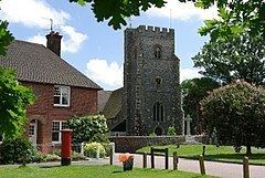
Church
The Church of St Mary is located next to the village green and contains six bells, five of which were made by Joseph Hatch in 1605, which makes them the oldest complete set by the same bellfounder in Kent. It was built in approximately 1294 and features a number of brasses, including that of Sir Robert de Setvans (d 1306). The stonework of its chancel windows exhibit a form of tracery, known as Kentish or split cusp tracery, which originates here. The tower is 14th century and the renovation was in 1875 by Oxford University architect George Edmund Street.
Railway Station
The Chartham railway station lies one stop west of Canterbury West and has regular trains to London stations including London Victoria station and London Charing Cross railway station. The HS1 trains also pass through the station but do not stop here.
Shalmsford Street
The village is contiguous with the smaller Shalmsford Street to the west, and was until recently the location of St Augustine's Mental Hospital, formerly known as the East Kent Lunatic Asylum. The site on which St Augustine's stood has now become a housing estate.
Here is the village's post office at 105 Shalmsford Street and Chartham Primary School in which as well as being a school, Chartham Parish meetings are held.
Chartham Hatch
Chartham Hatch is the northern upper part of the village, also known as a hamlet, of around 200 houses. It is surrounded by small woods and its orchards of apples and pears. Village Hall, formerly the school, is in the centre. The famous North Downs Way passes through the village.
Horton
Horton or Horton Manor is a tiny hamlet northeast by the Great Stour Way with its weir, Grade II listed manor house, and scheduled ancient monument manor chapel remains, later which became an oast house and agricultural storage area. In 844 King Æthelwulf of Wessex granted land at Horton to Ealdorman Eadred. A translation of the text of Charter S 319 reads: "Bounds of Horton. On the east: the wood which is called down-grove. On the west: the [arch]bishop and Lulla jointly. On the southern side: the land of Lulla at Chartham. On the north: the land of Beornwulf, which he possesses in eternity."
Mystole and Thruxted
These hamlets are south west along the Great Stour and to the south east. Mystole is rich in heritage due to its focal point, Mystole House, a remarkable 16th century historic building, with architectural Grade II* status and former appurtenances/outbuildings: Grade II* listed Mystole Coach House; its Park; listed orangery; tennis court; Archway Lodge; The Tetherings and Stable House. Thruxted itself has a large working farmhouse.