
Country Chile Founded 1933 Elevation 12 m (39 ft) Area 8,470 km² | Evacuated May 2008 Time zone CLT (UTC-4) Local time Wednesday 6:25 PM Number of airports 1 | |
 | ||
Weather 14°C, Wind N at 24 km/h, 77% Humidity Points of interest Pumalín Park, Corcovado Volcano, Michinmahuida, Yelcho Lake | ||
Chaite n chile natour cl abre tu puerta a la patagonia
Chaitén (/tʃaɪˈtɛn/, chahy-TEN) is a Chilean town, commune and former capital of the Palena Province in Los Lagos Region. The town is north of the mouth of Yelcho River, on the east coast of the Gulf of Corcovado. The town is strategically close to the northern end of the Carretera Austral, where the highway goes inland.
Contents
- Chaite n chile natour cl abre tu puerta a la patagonia
- Map of ChaitC3A9n Los Lagos Region Chile
- Chait n after volcano eruption hitchhiking the carretera austral in chile part 4
- Evacuation
- Reconstruction of Chaitn
- Nearby attractions
- References
Map of Chait%C3%A9n, Los Lagos Region, Chile
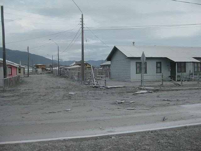
Chait n after volcano eruption hitchhiking the carretera austral in chile part 4
Evacuation
The town was evacuated in May 2008 when the Chaitén volcano erupted for the first time in more than 9,000 years. The eruption, which commenced May 2, became more violent on May 5, throwing up a high plume of ash and sulfurous steam that rose to 19 miles (31 km), from which ashfall drifted across Patagonia and over the Atlantic Ocean. During 2005 small earthquakes occurred below Chaitén and the nearby Liquiñe-Ofqui Fault Zone.
The town was completely flooded on May 12, 2008, after a lahar caused the banks of the Blanco River to overflow about 200 m (660 ft) on each side. Over the subsequent weeks, the river excavated a new course through Chaitén, completely destroying a significant part of it by July 2008. This process is still ongoing; it is unclear how extensive the damage will ultimately be. Some defensive work has been undertaken by the government, but they ultimately decided to abandon the town, relocating and compensating all residents. The provincial capital was provisionally moved to Futaleufú after the eruption breakout, but the capital shift was later on declared permanent. The future of the town has become a matter of political controversy in Chile.
Reconstruction of Chaitén
On February 25, 2009, the government announced plans to rebuild Chaitén 10 km (6.2 mi) north of its current location in a coastal place known as Santa Bárbara or "Fandango Norte". On March 3, 2009, construction work on the new town's administrative facilities started.
On April 9, 2011, president Sebastián Piñera announced a program to rebuild the town on its existing northern area, reversing plans by the previous administration to move the town to a different location farther north.
Nearby attractions
Nearby attractions include: