
Local time Friday 5:07 PM | Arrondissement Châteaulin Area 2.81 km² | |
 | ||
Intercommunality Pays de Châteaulin et du Porzay Weather 10°C, Wind SW at 18 km/h, 86% Humidity | ||
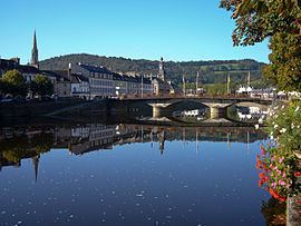
Châteaulin ([ʃɑ.to.lɛ̃]; Breton: Kastellin) is a commune in the Finistère department and administrative region of Brittany in north-western France. It is a sub-prefecture of the department.
Contents
- Map of 29150 ChC3A2teaulin France
- Geography
- Population
- Breton language
- Economy
- Personalities
- International relations
- References
Map of 29150 Ch%C3%A2teaulin, France
Geography
Châteaulin is located in a valley towards the center of the Finistère. Situated on the Aulne River, also Canal de Nantes à Brest there, Châteaulin is centrally located between Quimper to the south and Brest to the North. To the West, the Menez-Hom hills separate it from the Crozon peninsula and the Bay of Douarnenez which leads into the Atlantic Ocean.
Population
In French the inhabitants of Châteaulin are known as Châteaulinois.
Breton language
In 2008, 1.96% of primary-school children attended bilingual schools.
Economy
Châteaulin's economy rests on the twin bedrocks of food processing (salmon and poultry) and, to an ever greater extent, tourism. The Gendarmerie school on the outskirts of the town provides for a large number of families and the many recruits passing through the school provide the economic backbone of the town's night-life. A cake shop is also well-known within the area of Châteaulin,"Histoire de Macaron" is famous thanks to its tasty and wide range of macarons as well as the Java, created in 1907 by Mister Le Meur, which is a legend in the city.
Personalities
International relations
Châteaulin is twinned with: