
Elevation 1,708 m (5,604 ft) Province Province of Ávila Easiest route Hiking | First ascent ancestral | |
 | ||
Similar Canchal de la Ceja, Cueva Valiente, La Pinareja, Pico del Lobo, Jálama | ||
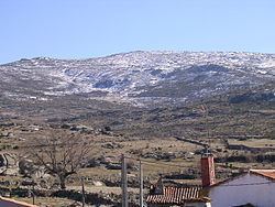
Cerro de Gorría is a 1.708 metres high mountain in Spain.
Contents
Map of Cerro de Gorr%C3%ADa, 05143, %C3%81vila, Spain
Geography
The mountain is located in Ávila Province, in the southern part of the autonomous community of Castile and León. It's the highest peak of the Sierra de Ávila, and is visible from a large part of the province.
Access to the summit
The summit can be accessed in one hour's walk from Pasarilla del Rebollar (1300 m, Valdecasa municipality). Its summit offers an interesting view on la Moraña, Amblés valley, Sierra Paramera, and la Serrota. In a clean day also Sierra de Guadarrama can be seen in the distance.
References
Cerro de Gorría Wikipedia(Text) CC BY-SA