
Mountain type Stratovolcano Easiest route hike | Last eruption Unknown Elevation 5,486 m Parent range Andes | |
 | ||
Similar Cochiquito Volcanic Group, Huanquihue Group, Cordón del Azufre, Falso Azufre, Cerro El Cóndor | ||
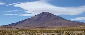
Cerro Tuzgle is a dormant stratovolcano in the Susques Department of Jujuy Province in Argentina. Tuzgle is a prominent volcano of the back-arc of the Andes and lies about 280 kilometres (170 mi) east of the main volcanic arc. Part of the Central Volcanic Zone of the Andes, it is 5,486 metres (17,999 ft) high above sea level and was constructed during different stages over a caldera and lava domes. Some major lava flows emanate from the summit crater, and one confirmed and one possible flank collapse unit as well as an ignimbrite sheet are associated with this volcano.
Contents
- Map of Cerro Tuzgle Jujuy Argentina
- Regional setting
- Local setting
- Composition and origin
- Activity
- Geothermal area and sulfur
- Climate and vegetation
- References
Map of Cerro Tuzgle, Jujuy, Argentina
The first volcanic activity of Tuzgle occurred 650,000 years ago and formed the Tuzgle Ignimbrite. Subsequently, lava domes were erupted and three lava flow units were named San Antonio, Azufre, and Tuzgle. The latest lava flows are dated at 17.5 and 1.5 Ma and volcanic activity may have continued into the Holocene. Several thermal springs are associated with the volcano, and some have been investigated for possible geothermal energy production. Sulfur was formerly mined on the mountain. Argentina's National Route 40 runs along the foot of the volcano.
Regional setting
Volcanic activity as well as general tectonism in the Central Andes is caused by the subduction of the Nazca plate beneath the South American plate at a horizontal pace of 10 centimetres per year (3.9 in/year) or 65 millimetres per year (0.081 in/Ms) forming the Central Volcanic Zone (CVZ) between latitude 16 and 28° south. Starting with activity in the Coastal Cordillera during the Jurassic (La Negra formation), this has caused spatially complex patterns of volcanic activity as well as the formation of the Altiplano-Puna highland with dimensions of 3,000 by 200 by 3.7–4 kilometres (1,864.1 mi × 124.3 mi × 2.3 mi–2.5 mi). Maximum deformation occurred during the late Miocene, with the formation of tectonic highs and lows. Small andesitic-basaltic volcanic centres of Quaternary age are associated with faulting. Seismic activity is still ongoing at the edge of the Puna, indicating thrusting. The crust beneath the CVZ is 70 kilometres (43 mi) thick.
A steepening of the subduction zone during the Late Miocene has been linked to an increase in volcanic activity and its westward migration, but it is unlikely that the pattern of activity in the southern Puna next to the Toro fault zone can be explained through this alone. A large low velocity and low seismic attenuation anomaly is found between 20 and 24° latitude south. Some geologic evidence, including geochemistry and geographic indicators, imply that lithospheric detachment did occur beneath the southern Puna.
Several major fault zones run across the Puna in the area, the most important being the Toro lineament to the south of Tuzgle. On this lineament, which has been subject to left-lateral displacement, are aligned several Pleistocene volcanoes, including Cordon Puntas Negras, Rincon, Tul Tul-Del Medio-Pocitos, Quevar, and Tastil (from north to south) (as well as the Negra Muerta volcanic complex). A segment named the Chorrillos fault is located directly south of Tuzgle. The segment of the Toro fault closest to Tuzgle has been active recently. Based on displacements along two monogenetic volcanoes, slip rates of 0.08–0.16 millimetres per year (0.000100–0.000200 in/Ms) have been estimated. The shoshonitic San Geronimo and Negro de Chorillos scoria cones and lava flows, as well as Antuco hot springs and travertine deposits (24°10′S 66°40′W), are also linked to the Toro fault zone and thermal waters flowing along it. Volcanic activity in the area occurred during two separate phases, the first one between 17.15 mya and 5.3 mya that generated a large number of volcanic centres, with a much more limited phase of activity since 1.5 mya associated with the Diaguita phase of Andean deformation.
Local setting
Tuzgle is a dormant stratovolcano in the Susques Department of Jujuy Province in Argentina. It is a prominent back-arc volcanic centre in the Andes located about 280 kilometres (170 mi) east of the main volcanic arc. Cerro Tuzgle lies within a geological depression in the Puna bordered by normal faults. The depression dates back to the Ordovician and slopes northward from 4,400 metres (14,400 ft) altitude on the southern side to 4,100 metres (13,500 ft) altitude on the northern side. A low gravity field anomaly is also found in the area. The basement consists of fractured rocks of Precambrian-Ordovician age, known as the Puncoviscana Formation and Faja Eruptiva, respectively, overlain with an impermeable Cretaceous unit named the Pirgua Formation. Volcanism in the area has existed since the Miocene, involving lava domes, ignimbrite eruptions (the 0.6 mya Tuzgle ignimbrite) and monogenetic volcanism. Volcanoes located south of Tuzgle are Aguas Calientes, Negro de Chorrillos and San Jeronimo. This region belongs to the back-arc region of the Andes, and the formation of melts is dependent on the melting of a heated mantle, whereas melt generation under the arc proper is dependent on the interaction between fluids and mantle rocks, leading to a reduction in their melting point. There is tomographic evidence that lithospheric delamination is currently underway beneath Tuzgle.
The highest unit of the Cerro Tuzgle volcano is the "Platform" unit, which covers a surface area of 0.5 square kilometres (0.19 sq mi) and is capped off by a well-preserved summit crater. It consists of well-preserved blocky lava flows with maximum thicknesses of 30 metres (98 ft). These are the youngest stages of Tuzgle volcanism and are well preserved. Radiating away from the central summit of the volcano, another lava flow unit forms the so-called Azufre synthem; these lava flows reach maximum thicknesses of 15 metres (49 ft) and are gray to brownish-red with some evidence of hydrothermal alteration. On the northwestern and southern flanks, lava emission from one emission area down steep slopes form the San Antonio synthem (unconformity bounded unit), with lava flows up to 30 metres (98 ft) thick. These San Antonio stage lavas have been cut by a 1.25 kilometres (0.78 mi) long fault scarp trending NNE-SSW that may have been formed by a mass failure of the Tuzgle edifice, which was then rebuilt by the Azufre stage lavas. On the northern flank is found a volcaniclastic fan with a surface area of 12 square kilometres (4.6 sq mi), a volume of 0.5 cubic kilometres (0.12 cu mi) and thicknesses of 30–40 metres (98–131 ft), presumably, considering its geochemical composition, formed by a mass failure of the San Antonio stage edifice. The scarp was probably formed by the same event but was not accompanied by explosive activity or a pyroclastic flow. This flank collapse may have been triggered by magma injection. A structure on the southern side of the volcano may also be a collapse scar, but no deposit is identifiable. A weakness zone running east-west cuts across the Tuzgle edifice, and some volcanic features are aligned along this weakness. A 5-kilometre (3.1 mi) wide feeder dyke has been modelled and is associated with this weakness zone. The youngest- and best-exposed lava flow of Cerro Tuzgle originated in a group of three depressions bordered by 1–2 metres (3 ft 3 in–6 ft 7 in) scoria ridges. These depressions, presumably eruption fissures, are arranged in en echelon order. This youngest lava flow has a structure between block lava and aa lava. In non-volcanic terms patterned ground is found resulting from pre-glacial processes.
Tuzgle is underpinned by a plateau formed by mostly unwelded ignimbrites, while the so-called "Pre-platform", "Platform", "Post-platform" and "Young Flow" units make up the central volcano. The moderately crystal-rich ignimbrite has a volume of 0.5 cubic kilometres (0.12 cu mi) and is 80 metres (260 ft) thick, and was presumably emitted from a caldera now buried by the Cerro Tuzgle edifice. Circular lava domes (50 metres (160 ft) thick at a maximum) are found in the southeastern, eastern and northern sector of the volcano and may have formed along ring dykes associated with the caldera. A high electrical conductivity zone beneath Tuzgle may constitute a magma chamber embedded within porous material containing saline fluids with the bottom at a depth of at least 22 kilometres (14 mi) and the top at a depth of 8 kilometres (5.0 mi). Crustal silicic magmas gave rise to ignimbrites from depths of 15–18 kilometres (9.3–11.2 mi). The magma chamber appears to be placed next to a crustal decollement at 20 kilometres (12 mi). Thermobarometric data also indicate a magma origin depth of 10–20 kilometres (6.2–12.4 mi). Beneath Tuzgle, a high seismic attenuation plume rises from an earthquake cluster at 200 kilometres (120 mi) depth up to the volcano and is probably linked to asthenospheric upwelling.
In the ground beneath Tuzgle, seismic tomography has found a 18-kilometre (11 mi) thick layer of low velocity, probably linked to a lower density of the rock, at a depth of 40 kilometres (25 mi). Magnetotelluric analysis has found several deep (1–85 kilometres (0.62–52.82 mi)) conductive layers and one shallow one, possibly formed by the aquifers in the area. Another high conductivity body southeast of Tuzgle is associated with the Toro lineament and the Queva volcano and may also be hydrothermal in origin.
Composition and origin
The Tuzgle volcano proper is constructed from an older rhyodacite-mafic series and a more recent series constructed from andesites alone. These and neighbouring shoshonitic centres are formed from magmas with crustal contamination. Isotope analysis of magmatic rocks have shown La/Nb ratios of 1.3–1.6 and Ba/Ta ratios of 160–260, lower than in the main volcanic front. The overall chemical composition is potassium-rich calc-alkaline. Thermobarometry indicates that the older magmas crystallized at pressures of 0.25–0.5 gigapascals (36,000–73,000 psi) while younger ones crystallized at 0.5–0.6 gigapascals (73,000–87,000 psi) and temperatures of about 760 °C (1,400 °F). These magma compositions indicate that the magmas are the result of complex mixing processes and also involve the transitional nature of the mantle beneath Tuzgle, where the more northern steep slab encounters the shallower southern subducting slab. Crystal fractionation and melting of upper crustal rocks further complicate the pattern. The lava domes which were erupted from the ground after the Tuzgle ignimbrite have volumes of 3.5 cubic kilometres (0.84 cu mi), while the Platform and subsequent units have volumes of 0.5 cubic kilometres (0.12 cu mi). The lava domes and San Antonio lava flows have porphyritic surfaces. San Antonio lavas contain large plagioclase xenocrystals and xenoliths. The ignimbrite contains Ordovician lithic fragments and 10–20% pumice. Its eruption was presumably linked to high mantle melt rates; the resulting mafic magmas induced the generation of large amounts of silicic melts. Lower mantle melt rates would form mafic melts that incorporate silicic melts before erupting.
Activity
The oldest activity is an ignimbrite erupted 0.65 ± 0.18 mya, called the Tuzgle ignimbrite. On the rim of the caldera left by this eruption is a lava dome complex named the Old Complex Unit. 0.3 ± 0.1 mya ago effusive activity commenced with the Pre-platform and Platform units that were then followed by a tectonic event that dissected these units. Afterwards, the Post-platform and Young Flow Units were erupted. The youngest unit is latitic and was dated 0.1 ± (0.1-0.3) mya ago. This unit may be Holocene or Pleistocene–Holocene in age. It is possible that the continuing activity of the Chorrillos fault zone is compressing the magma chamber and feeder dyke of Tuzgle, thus impeding eruptive activity. The well-preserved summit crater and youthful-looking lava flows have been assigned Holocene ages.
Geothermal area and sulfur
The area around Cerro Tuzgle has a high geothermal gradient of 0.4 degrees Celsius per metre (0.22 °F/ft), and geothermal studies indicate temperatures of over 400 °C (752 °F) at depth. Hot springs (with temperatures around 57 °C (135 °F)) are also found in the area. The Miocene ignimbritic Trinchera formation may be a geothermal reservoir and the later Miocene–Pliocene sedimentary Pastos Chicos Formation a seal above it. This geothermal reservoir is 50–300 metres (160–980 ft) deep beneath the earth and 100–600 metres (330–1,970 ft) thick. A deeper reservoir is also presumed to exist at a depth of 2–4 kilometres (1.2–2.5 mi). Selected hot springs include Tuzgle–Agua Caliente (40–56 °C (104–133 °F), 24°01′44.46″S 66°31′24.42″W), Las Minas (21 °C (70 °F)) Pompeya (24°14′48.12″S 66°21′45.3″W), Mina Betty (24°06′31.26″S 66°27′28.92″W) and Tocomar (24°11′18.9″S 66°33′11.76″W). The water enters the geothermal system in ridges above 4,500 metres (14,800 ft) altitude which are not covered by impermeable layers. Two maars have been found in the Tocomar area. Further, the Antuco travertine and hot springs may be associated with heat flow from the Tuzgle volcanic system.
The Tuzgle area has been identified as a possible site for geothermal energy production in Argentina with an energy potential of <0.1 megawatts (130 hp). These were explored in the 1980s and 1990s, yielding evidence of temperatures 133–142 °C (271–288 °F). In 2015 a company named Geotermina Andina had six concessions in the area for geothermal drilling. The location of a main power line between Chile and Argentina close to Tuzgle may assist in power generation, and some hot springs could be exploited for tourism.
Sulfur deposits generated from hydrothermal alteration are found on Cerro Tuzgle. They are mostly associated with the Azufre synthem and were previously mined on the southern, eastern and western flanks of the volcano. The mines are now abandoned. Arsenic is also found in the groundwater and presumably comes from Tuzgle.
Climate and vegetation
The climate of the Puna is arid, with most precipitation originating in the Amazon basin. During the Last Glacial Maximum, a humid period occurred (possibly directed by orbital changes and monsoon activity), whereas preceding glacial periods were associated with dry phases in travertine deposits at Antuco. Temperatures are usually less than 5 °C (41 °F) in the Puna with extremes of 16 – −4 °C (61–25 °F). Winds usually blow from the west in the dry winter season, with wetter easterly winds arriving during summer. Precipitation in San Antonio de los Cobres (24°13′32″S 66°19′9″W) southeast of Tuzgle amounts to 100 millimetres per year (0.12 in/Ms).
Vegetation is largely missing from the Puna plateau in the area of Tuzgle, which has facilitated the mapping of lava flows from Cerro Tuzgle. A steppe-like vegetation dominated by herbs grows on the slopes of Tuzgle, containing taxa like Festuca, Poa and Stipa as elsewhere on the Puna.