
Elevation 1,425 m | ||
 | ||
Road Washington State Route 410 Similar Chinook Pass, Blewett Pass, Sherman Pass, Cascade Range, Manastash Ridge | ||
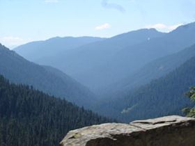
Cayuse Pass (el. 4675 ft./1425 m.) is a mountain pass in the Cascade Mountains in the state of Washington.
Map of Cayuse Pass, Washington 98022, USA
The pass is about 32 miles (51 km) southeast of Enumclaw on State Route 410. The intersection with State Route 123 is at the pass.
The pass carries State Route 410 and State Route 123 between Packwood and Enumclaw. Because of the high elevation, Cayuse Pass is usually closed in November due to very heavy snow and significant avalanche danger. It usually opens in mid May and is not uncommon to have a snow depth at the summit of up to 15 feet.
As part of the All-American Road program, Route 410 through Cayuse Pass has been designated by the U.S. government as the Chinook Scenic Byway.
References
Cayuse Pass Wikipedia(Text) CC BY-SA