
Prominence 284 ft (87 m) | Topo map USGS Sedona | |
 | ||
Elevation 4,967 ft (1,514 m) NGVD 29 Similar Bell Rock, Miller Peak, Thimble Peak, Carr Peak, Chiricahua Peak | ||
Cathedral rock trail sedona arizona hd video
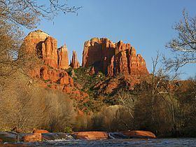
Cathedral Rock is a famous landmark on the Sedona, Arizona skyline, and is one of the most-photographed sights in Arizona, USA. Cathedral Rock is located in the Coconino National Forest in Yavapai County, about a mile (1.6 km) west of Arizona Route 179, and about 2.5 miles (4.0 km) south of the "Y" intersection of Routes 179 and 89A in uptown Sedona. The summit elevation of Cathedral Rock is 4,967 feet (1,514 m).
Contents
Map of Cathedral Rock, Arizona 86351, USA
The Cathedral Rock trail (USFS Trail #170) is a popular short, steep ascent from the Back O' Beyond trailhead to the saddle points or "gaps" in Cathedral Rock.
Geologically, Cathedral Rock is carved from the Permian Schnebly Hill formation, a redbed sandstone formed from coastal sand dunes near the shoreline of the ancient Pedregosa Sea. Ripple marks are prominent along the lower Cathedral Rock trail, and a black basalt dike may be seen in the first saddle.
Cathedral Rock was called "Court House Rock" on some early maps, and Courthouse Butte was called "Church House Rock", which has caused endless confusion ever since.