
OS grid reference TG380210 Sovereign state United Kingdom Local time Monday 5:04 PM | Civil parish Catfield Area 10.02 km² Dialling code 01692 | |
 | ||
Population 943 (parish, 2011 census) Weather 7°C, Wind NW at 16 km/h, 89% Humidity | ||
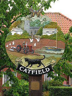
Catfield is a village and a civil parish in the English county of Norfolk. The village is 19.7 miles (31.7 km) south-east of Cromer, 17.3 miles (27.8 km) north-east of Norwich and 136 miles (219 km) north-east of London. The village lies 2.7 miles (4.3 km) south-south-east of the nearby town of Stalham. The nearest railway station is at Worstead for the Bittern Line which runs between Sheringham, Cromer and Norwich. The nearest airport is Norwich International Airport. The village is situated a little west of the A149 King’s Lynn to Great Yarmouth road. The parish had in 2001 census, a population of 848, increasing to 943 at the 2011 Census. For the purposes of local government, the parish falls within the district of North Norfolk.
Contents
Map of Catfield, UK
History
Catfield has an entry in the Domesday Book of 1085. In the great book Catfield is recorded by the names Cate(s)felda, the main landholders being Roger Bigod and Count Alan.
Church of All Saints
The parish church of Catfield is called All Saints. Most of the building dates from the 14th century. On the rood screen there are sixteen paintings of kings. On the north wall of the sanctuary there is a tablet by the sculptor William Groves depicting a peepul tree at the top and a sheathed sword below dedicated to Lt Thomas Cubitt who died in 1848. Cubitt, who was a soldier died in his country’s cause before Multan, a town in the Punjab, India. The church is a Grade I listed building